THE CLOVIS
CULTURE:
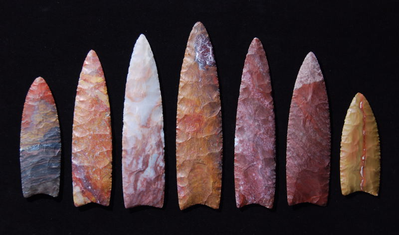
The Clovis culture is a prehistoric Paleo-Indian culture,
named after distinct stone tools found at sites near Clovis, New
Mexico, in the 1920s and 1930s. The Clovis culture appears around
11,500�11,000 uncal (uncalibrated radiocarbon years before present),
at the end of the last glacial period, and is characterized by the
manufacture of "Clovis points" and distinctive bone and ivory tools.
Archaeologists' most precise determinations at present suggest that
this radiocarbon age is equal to roughly 13,200 to 12,900 calendar
years ago. Clovis people are considered to be the ancestors of most
of the indigenous cultures of the Americas.
Clovis Point Picture, Paleoindian
Map.
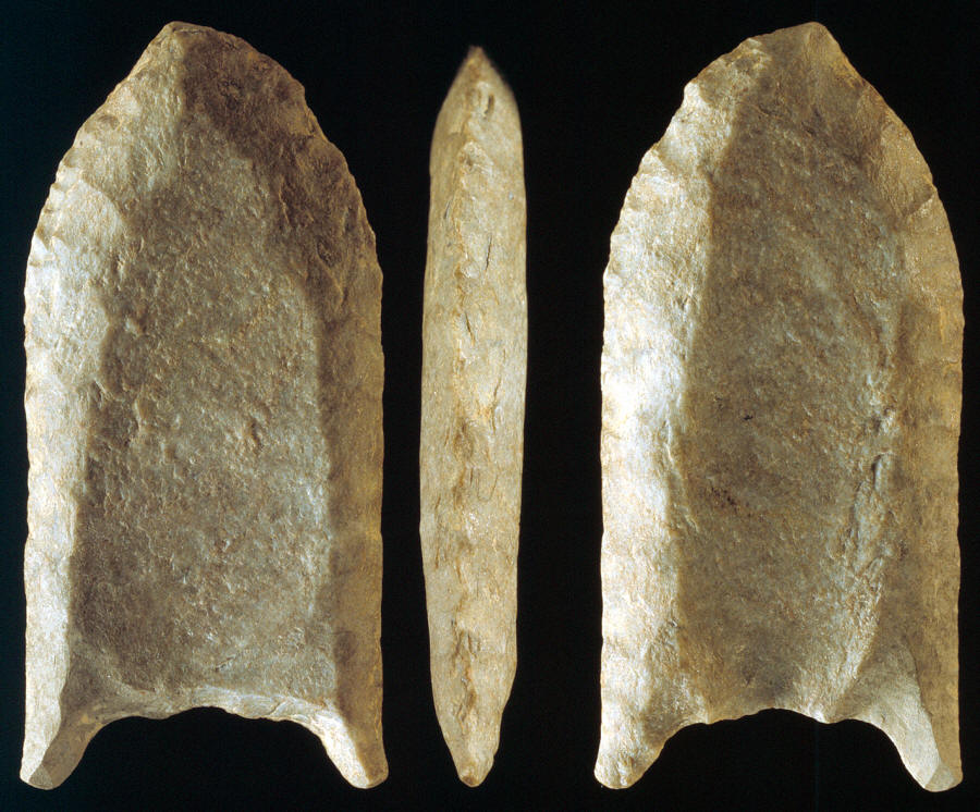
THE FOLSOM TRADITION:
The Folsom Complex is a name given by archaeologists to a specific
Paleo-Indian archaeological culture that occupied much of central
North America. The term was first used in 1927 by Jesse Dade Figgins,
director of the Colorado Museum of Natural History.
Folsom Point Pictures
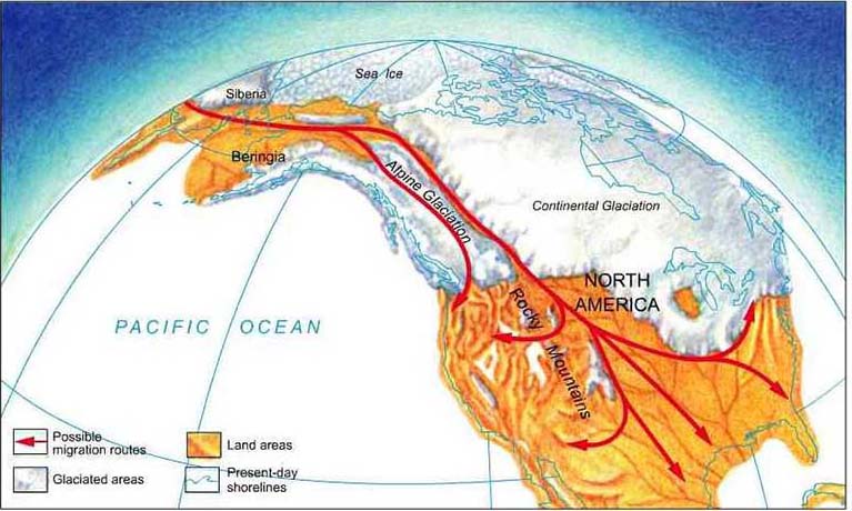
THE MONTE VERDE ISSUE:
(Chile): Monte Verde is an archaeological site in southern
Chile, located near Puerto Montt, Southern Chile, which has been
dated to 14,800 years BP. This dating adds to the evidence showing
that the human settlement of the Americas pre-dates the Clovis
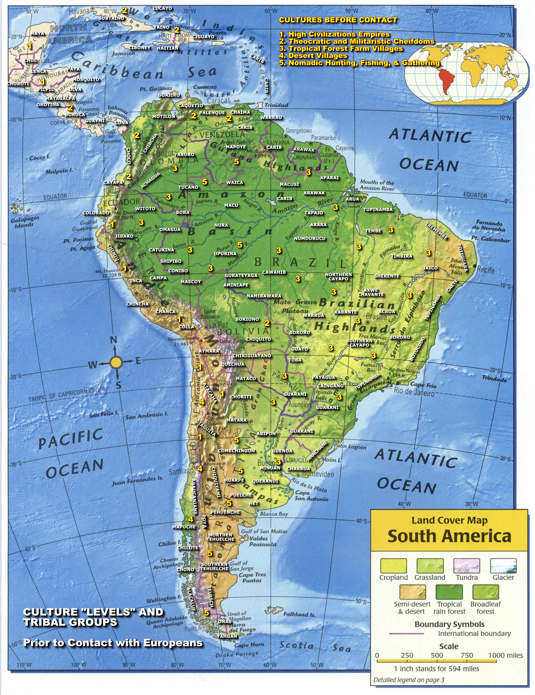
culture by roughly 1000 years. South America Indians Map -
Monte Verde by Tom Dillehay
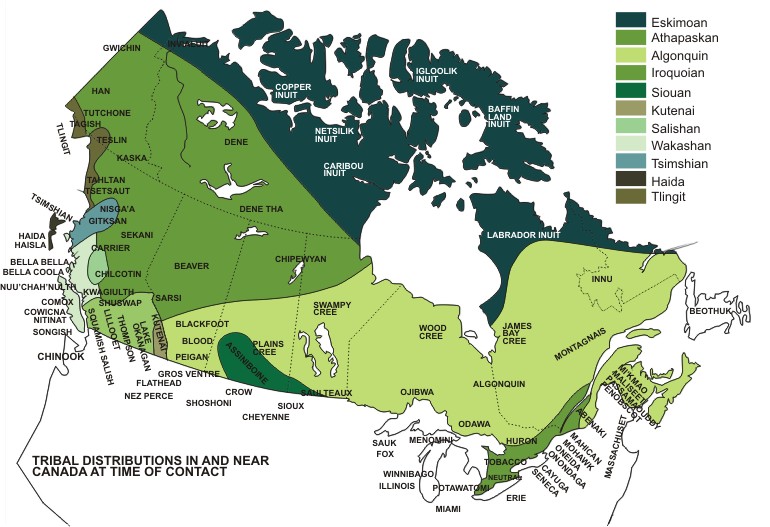
CANADA FIRST NATIONS:
The histories of the First Nations peoples are fundamentally
connected to the physical identity of Canada. The vastness and
variety of Canada's climates, ecology, vegetation, fauna, and
landforms separate, join, and define ancient peoples, as implicitly
as cultural or linguistic divisions. Canada is surrounded north,
east, and west with coastline and since the last ice age Canada has
consisted of several distinct forest regions. Adaptability
is the essential component for survival within these demanding
environments. Historic geographical models and population estimates
are supplemented by oral histories, archaeological and
anthropological evidence to derive knowledge of First Nations
dwellings, food sources, and technology. Understanding how a people
survived within their environment provides a greater insight into
their history.
A History of the Native People in Canada Volume 1,
A History of the Native People in Canada Volume 2, Canadian Indians Map
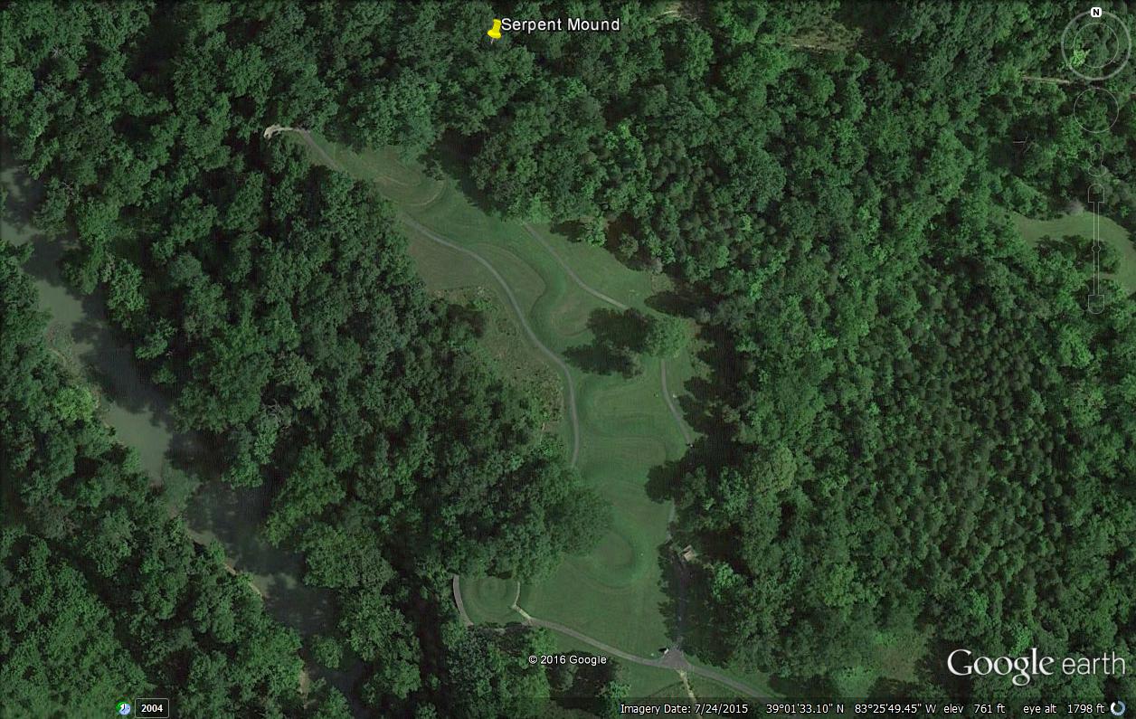
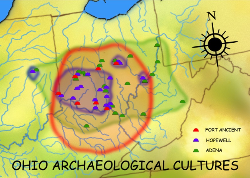
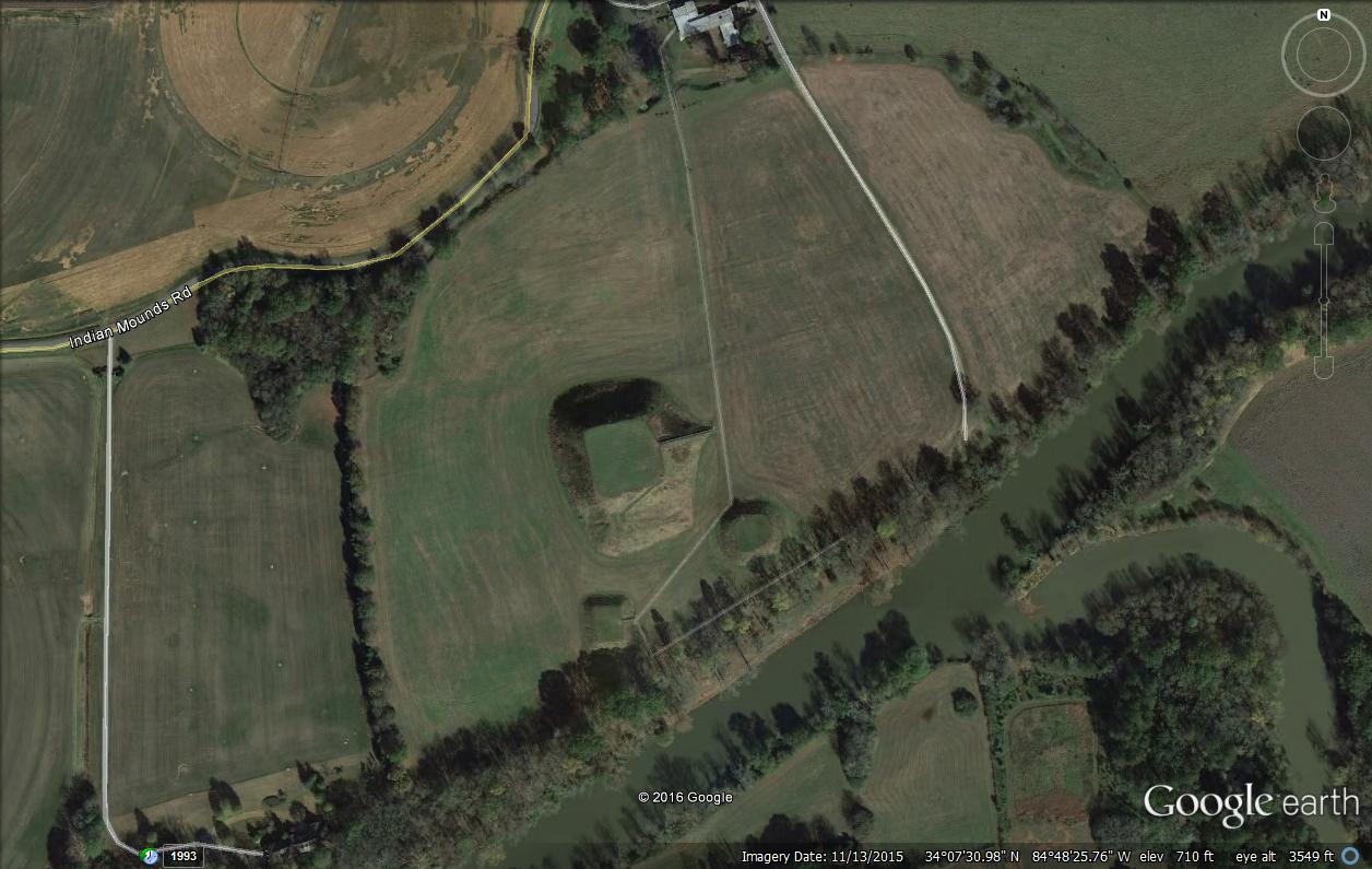
MOUNDS BUILDERS CULTURE:
Mound Builders,
were people who built mounds in E central North America,
concentrating in the Mississippi and Ohio river valleys, from the
early 6th cent. to historic times. Probably ancestors of Native
Americans found in that region by Europeans, they were politically
diverse and developed distinct cultures. Artifacts indicate fine
stone carving, pottery making, and weaving, as well as widespread
trade in copper, mica, and obsidian. The mounds vary in size (1�100
acres/0.4�40 hectares), shape (geometric or animal effigy, e.g.,
Serpent Mound in Ohio), and purpose (burial, fortress, or totem.
Excellent Satellite
Pictures by James Q Jacobs , 1999.
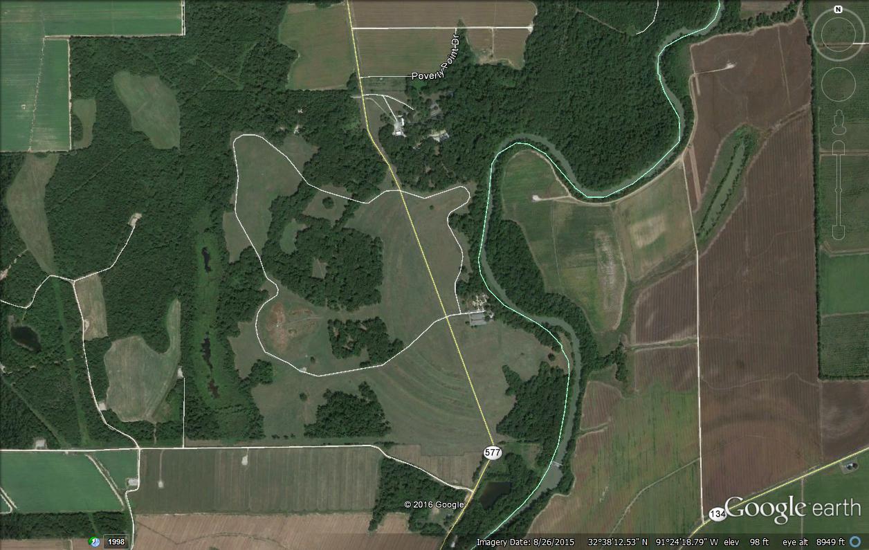
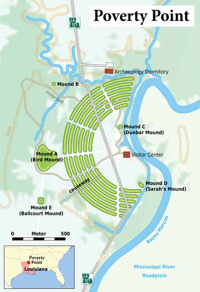
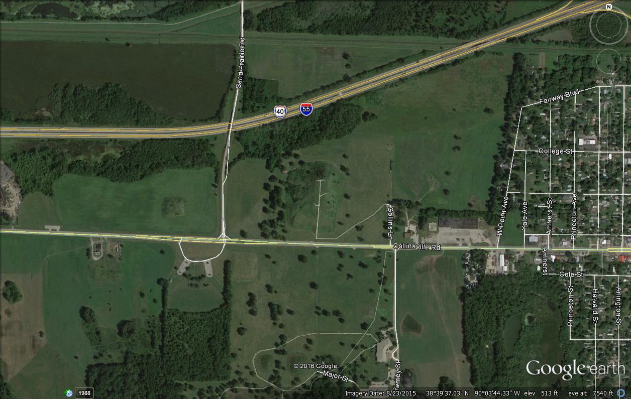
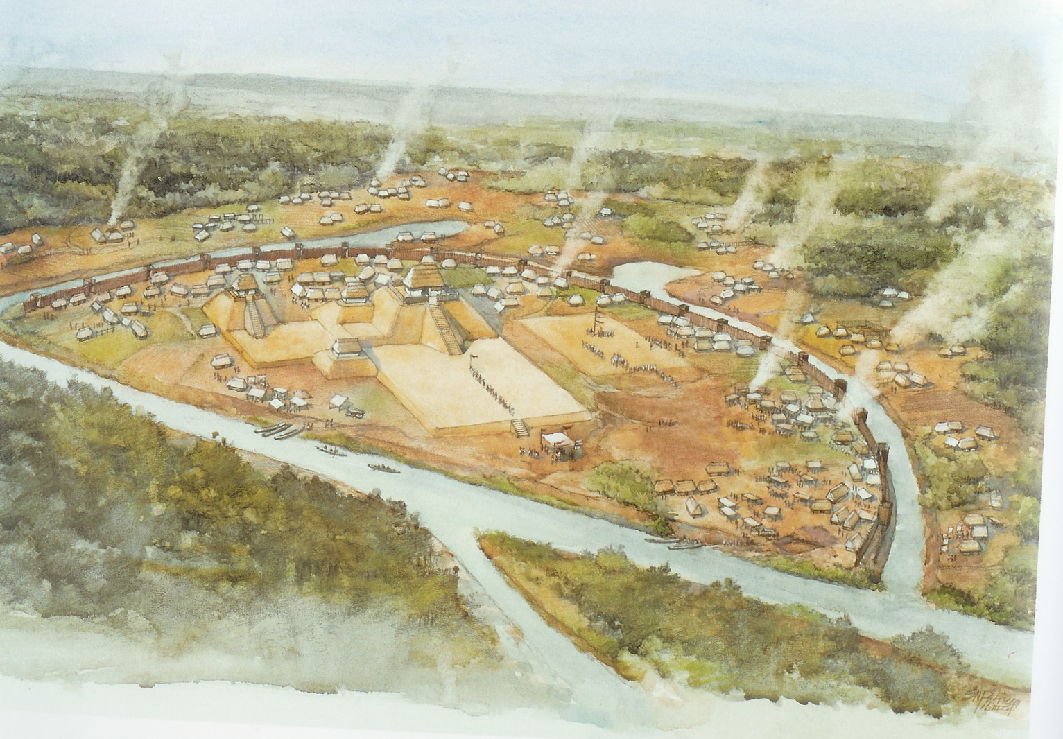
POVERTY POINT:
Poverty Point culture is an archaeological culture that corresponds
to an ancient group of Indigenous peoples who inhabited the area of
the lower Mississippi Valley and surrounding Gulf coast from about
2200 BC - 700 BC. Archeologists have identified more than 100 sites
as belonging to this mound builder culture, which also formed a
large trading network throughout the eastern part of what is now the
United States.
Satellite Picture (Poverty Point)
View Reconstruction,
Excellent Satellite
Pictures by James Q Jacobs , 1999
ADENA CULTURE: The Adena culture
was a Pre-Columbian Native American culture that existed from 1000
to 200 BC, in a time known as the Early Woodland period. The Adena
culture refers to what were probably a number of related Native
American societies sharing a burial complex and ceremonial system.
The Adena were notable for their agricultural practices, pottery,
artistic works and extensive trading network, which supplied them
with a variety of raw materials, ranging from copper from the Great
Lakes to shells from the Gulf Coast.
Satellite Picture (Criel Mound)
Satellite Picture (Serpent Mound)
Adena Map, Excellent Satellite
Picturesby James Q Jacobs , 1999
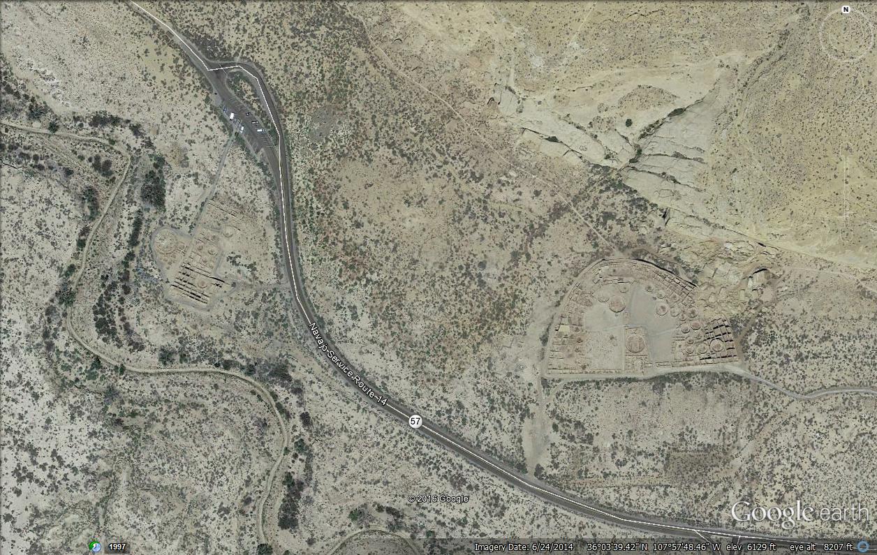
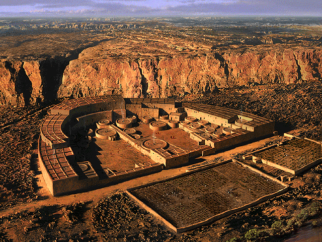
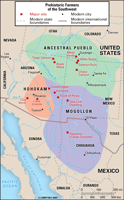
CHACO CANYON: Chaco Canyon was a major center of ancestral Puebloan culture. It was a hub of ceremony, trade, and
administration for the prehistoric Four Corners area - unlike
anything before or since. Chaco is remarkable for its monumental
public and ceremonial buildings, and its distinctive architecture.
Building construction, and creating the associated Chacoan roads,
ramps, dams, and mounds, required a great deal of well organized and
skillful planning, designing, resource gathering, and construction.
Excellent Satellite
Pictures. More
Pictures by James Q Jacobs , 1999.
Satellite Picture (Chaco Canyon)
Chaco Canyon Reconstruction, The
Southwest Ancient Map. Ancestral
Puebloans Immigration.
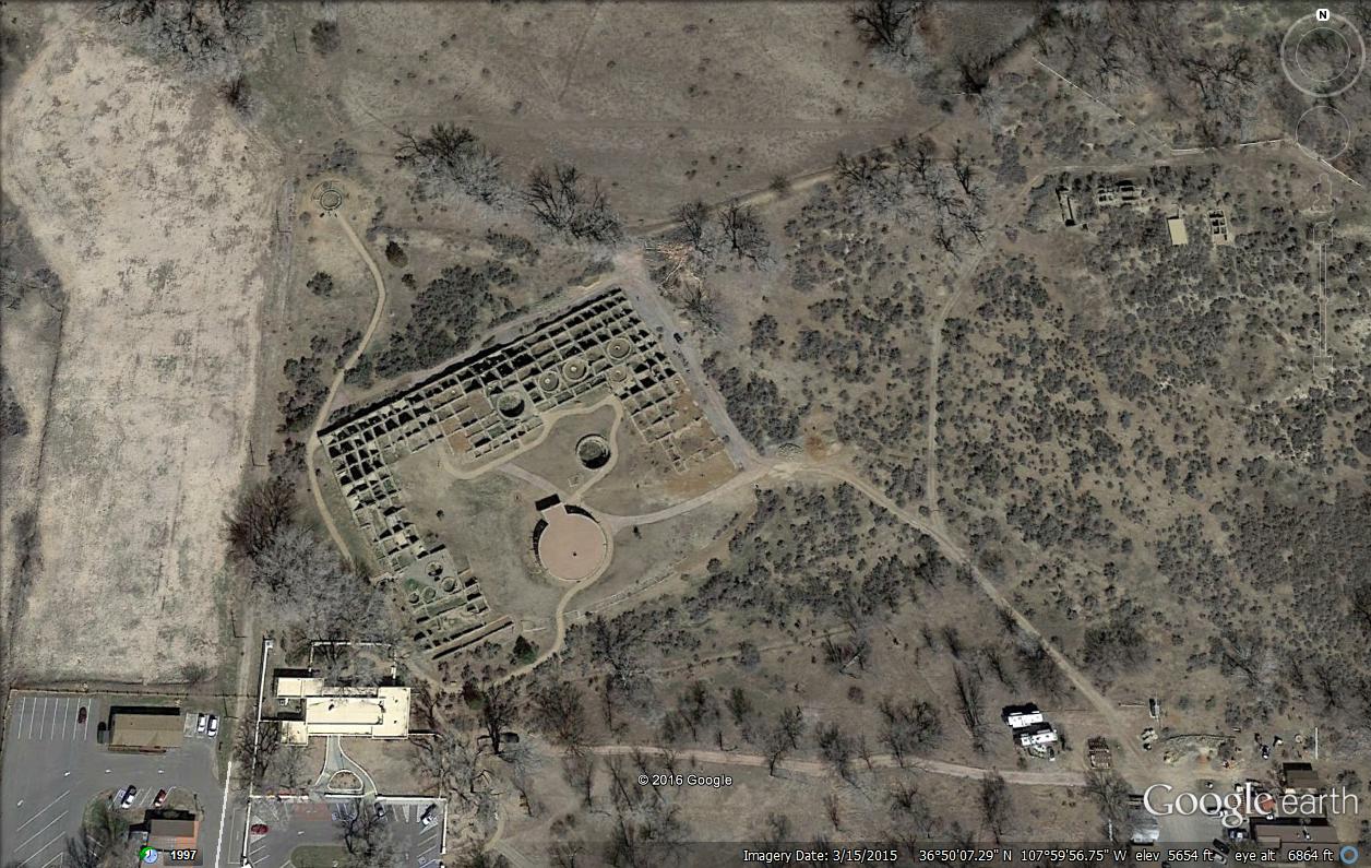
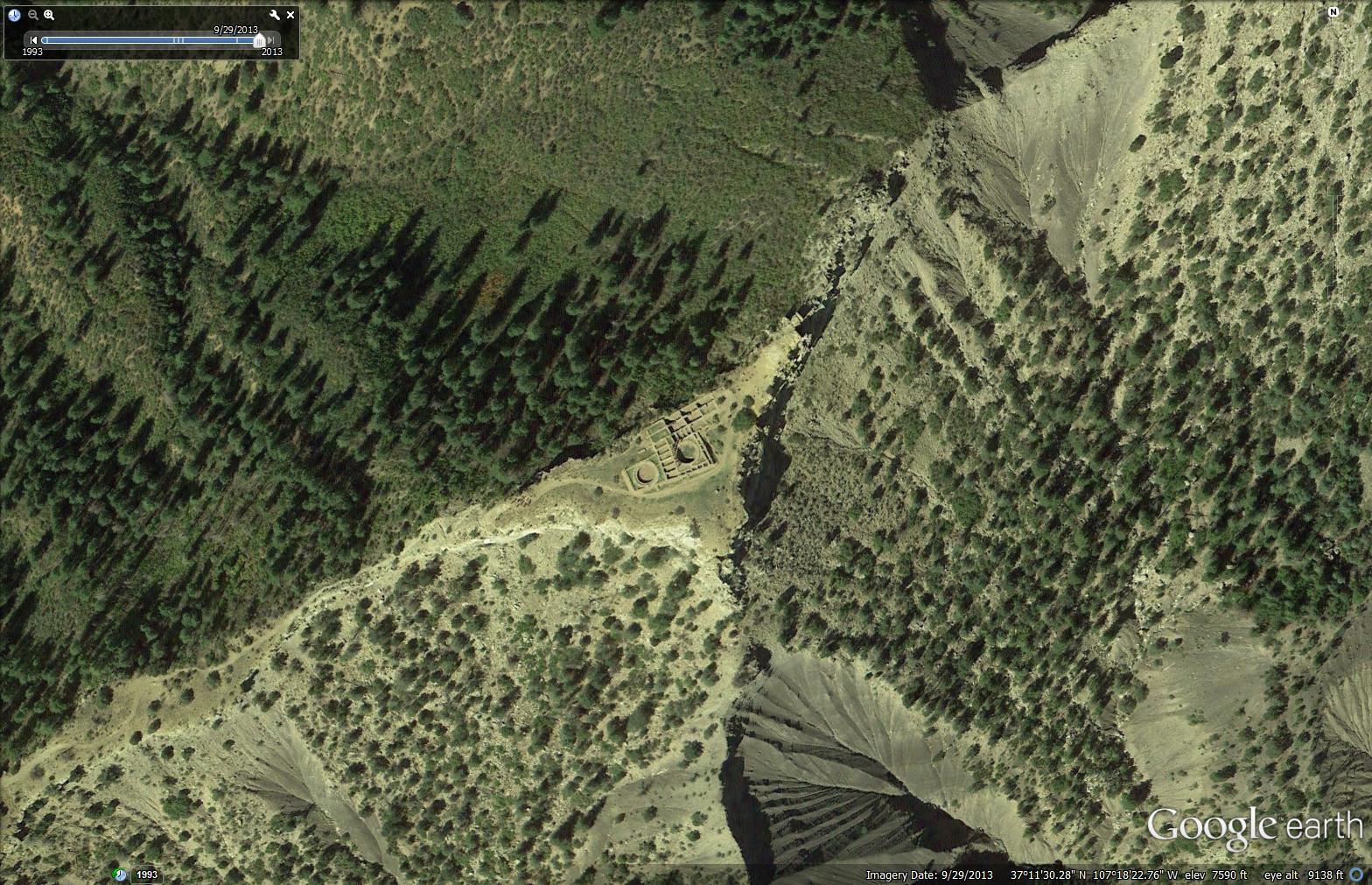
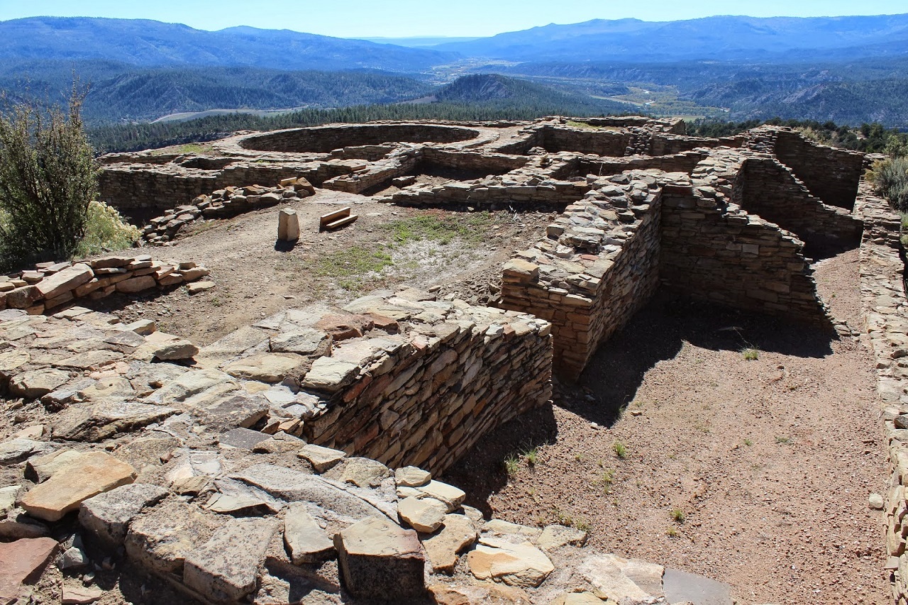
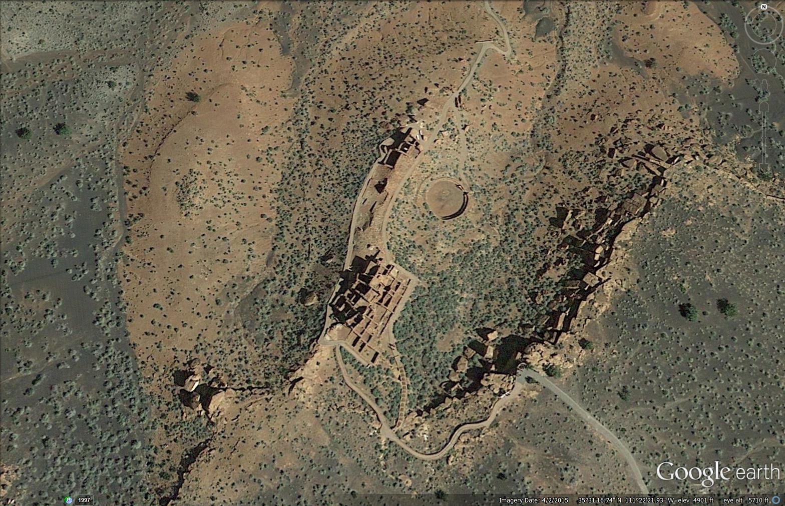
CHIMNEY ROCK: Housing approximately 2,000 ancient Pueblo Indians
between A.D. 925 and 1125, the settlement included a Great House
Pueblo with round ceremonial rooms, known as kivas, and 36
ground-floor rooms. A grizzly bear jaw found in one of the rooms
when excavated suggested a reverence for the animal, and modern
Chaco oral history suggests that the Bear clan originated in the
Chimney Rock area. Satellite Picture,
Chimney Rock, The
Southwest Ancient Map. Ancestral
Puebloans Immigration,
More
Pictures by James Q Jacobs , 1999.
AZTECS RUINS: The Aztec Ruins National Monument preserves
Ancestral Puebloan structures in North-Western New Mexico, United
States, located close to the town of Aztec and Northeast of
Farmington, near the Animas River. Salmon Ruins and Heritage Park,
with more Puebloan structures, lies a short distance to the south,
just west of Bloomfield near the San Juan River. The buildings date
to the 11th to 13th centuries, and the misnomer attributing them to
the Aztec civilization can be traced back to early American settlers
in the mid-19th century.
Satellite Picture, Aztec Ruins, The
Southwest Ancient Map. Ancestral
Puebloans Immigration,
More
Pictures by James Q Jacobs , 1999.
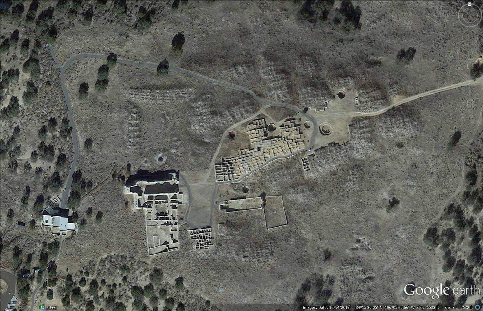
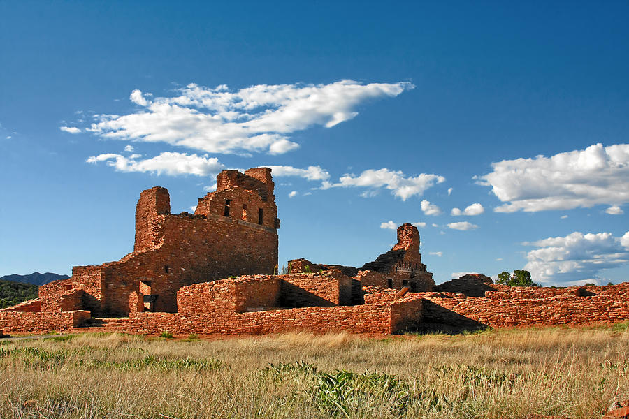
GRAND QUIVIRA: The Gran Quivira
unit of Salinas Pueblo Missions National Monument is the biggest of
the three units at 611 acres. Prior to Spanish contact, Gran Quivira
was a vast city with multiple pueblos, and kivas. During the
excavation, an older Circular Pueblo was discovered. First contact
with the Spanish probably happened in 1583 with the arrival of Don
Antonio de Espejo who mentions a settlement that sounds very similar
to Gran Quivira. Satellite Picture,
More
Pictures by James Q Jacobs , 1999,
Grand Quivira, The
Southwest Ancient Map. Ancestral
Puebloans Immigration.
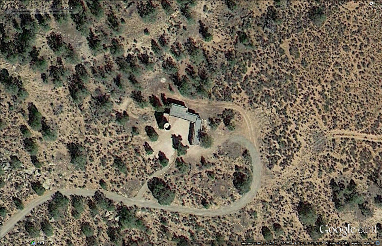
CROW CANYON
ARCHEOLOGICAL CENTER: Pueblo Indians' historical perspectives
are shaped by their deep cultural heritage, kept alive through oral
tradition. Archaeologists' understanding of Pueblo history derives
primarily from the application of the scientific method. In this
series of videos, Pueblo people and archaeologists discuss aspects
of Pueblo history and culture from their different�but often
complementary�perspectives.
More
Pictures by James Q Jacobs , 1999, Satellite
Picture,
Crow Canyon Ruins, The
Southwest Ancient Map. Ancestral
Puebloans Immigration,
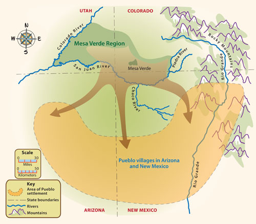
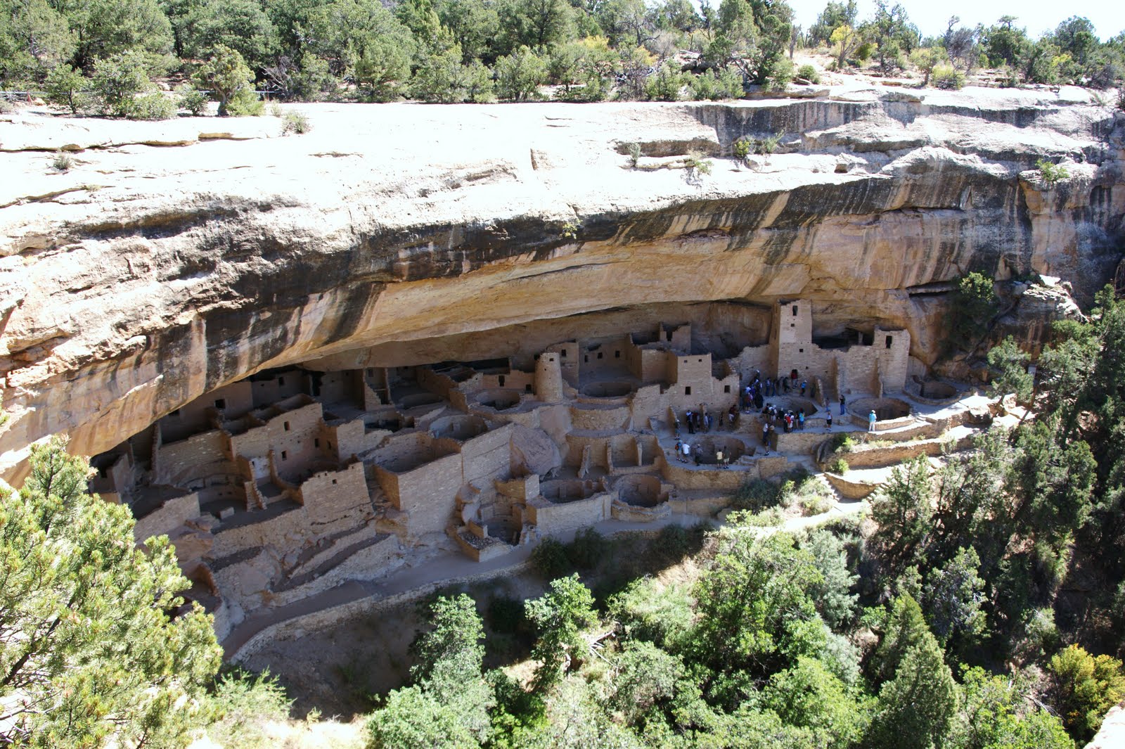
MESA VERDE: The Mesa Verdeans survived using a combination of
hunting, gathering, and subsistence farming of crops such as corn,
beans, and squash. They built the mesa's first pueblos sometime
after 650, and by the end of the 12th century, they began to
construct the massive cliff dwellings for which the park is best
known. By 1285, following a period of social and environmental
instability driven by a series of severe and prolonged droughts,
they abandoned the area and moved south to locations in Arizona and
New Mexico, including Rio Chama, Pajarito Plateau, and Santa Fe.
Excellent Satellite
Pictures. More
Pictures by James Q Jacobs , 1999. Satellite
Picture, Mesa Verde, The
Southwest Ancient Map. Ancestral
Puebloans Immigration.
SINAGUA:
Colton also distinguished between two different Sinagua cultures.
The Northern Sinagua were loosely centered in the highlands around
Flagstaff, with Walnut Canyon National Monument, Wupatki National
Monument, and Elden Pueblo the best-known publicly accessible sites.
The Southern Sinagua inhabited lower elevations across the Verde
Valley of central Arizona; Montezuma Castle National Monument,
Montezuma Well, Tuzigoot National Monument, Palatki and Honanki
Archaeological Sites, and the V-Bar-V Petroglyph Site are notable
localities open to the public.
More
Pictures by James Q Jacobs , 1999,
Satellite Picture, The
Southwest Ancient Map. Ancestral
Puebloans Immigration.
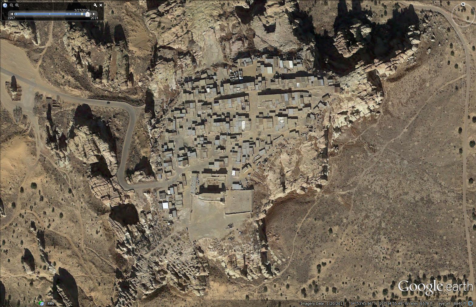
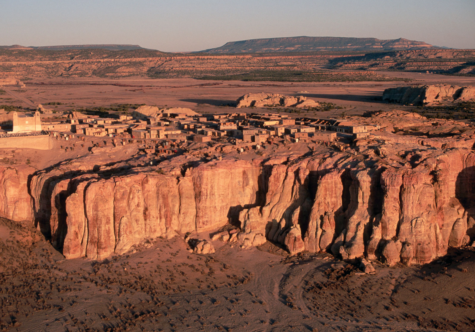
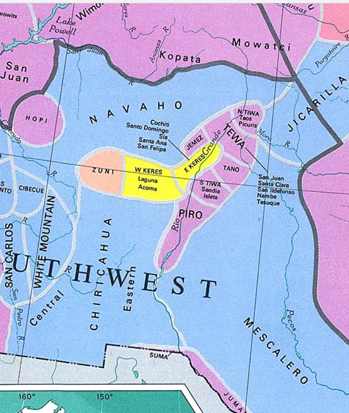
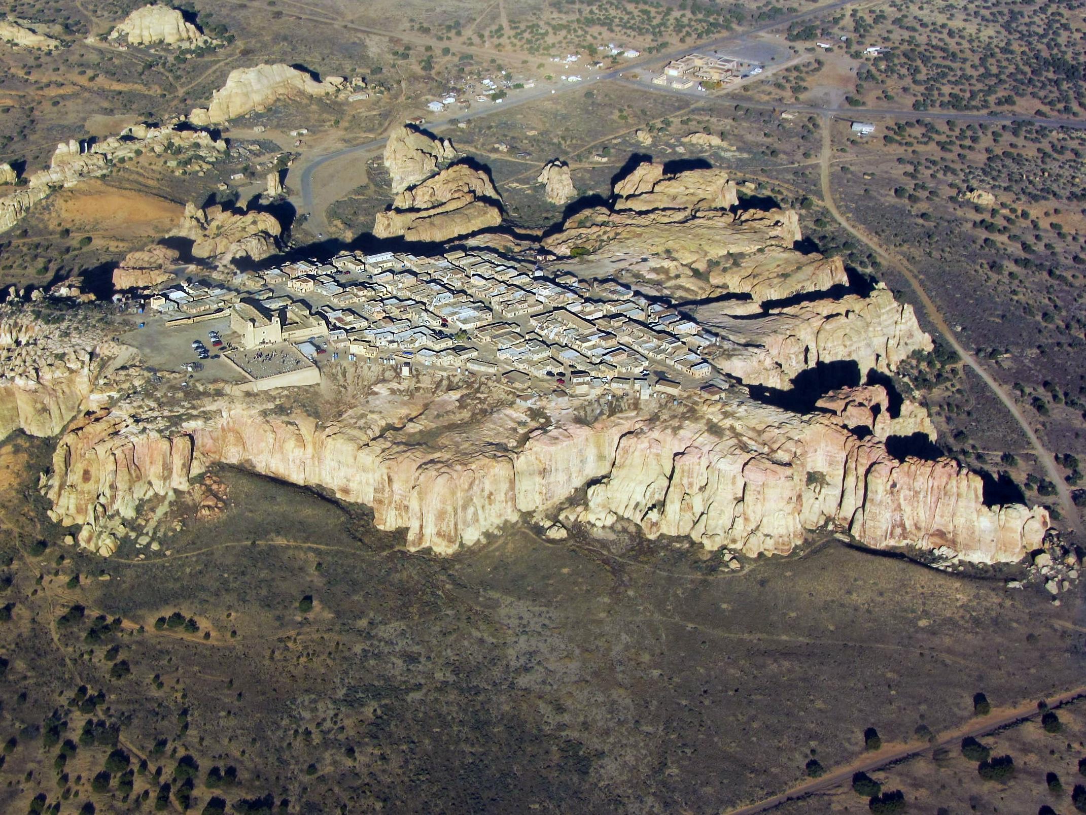
ACOMA: Pueblo
people are believed to have descended from the Anasazi, Mogollon,
and other ancient peoples. These influences are seen in the
architecture, farming style, and artistry of the Acoma. In the 13th
century, the Anasazi abandoned their canyon homelands due to climate
change and social upheaval. For upwards of two centuries, migrations
occurred in the area. The Acoma Pueblo emerged by the thirteenth
century. This early founding date makes Acoma Pueblo one of the
earliest continuously inhabited communities in the United States.
More
Pictures by James Q Jacobs , 1999,
Satellite Picture,
Acoma City, The
Southwest Ancient Map. Ancestral
Puebloans Immigration.
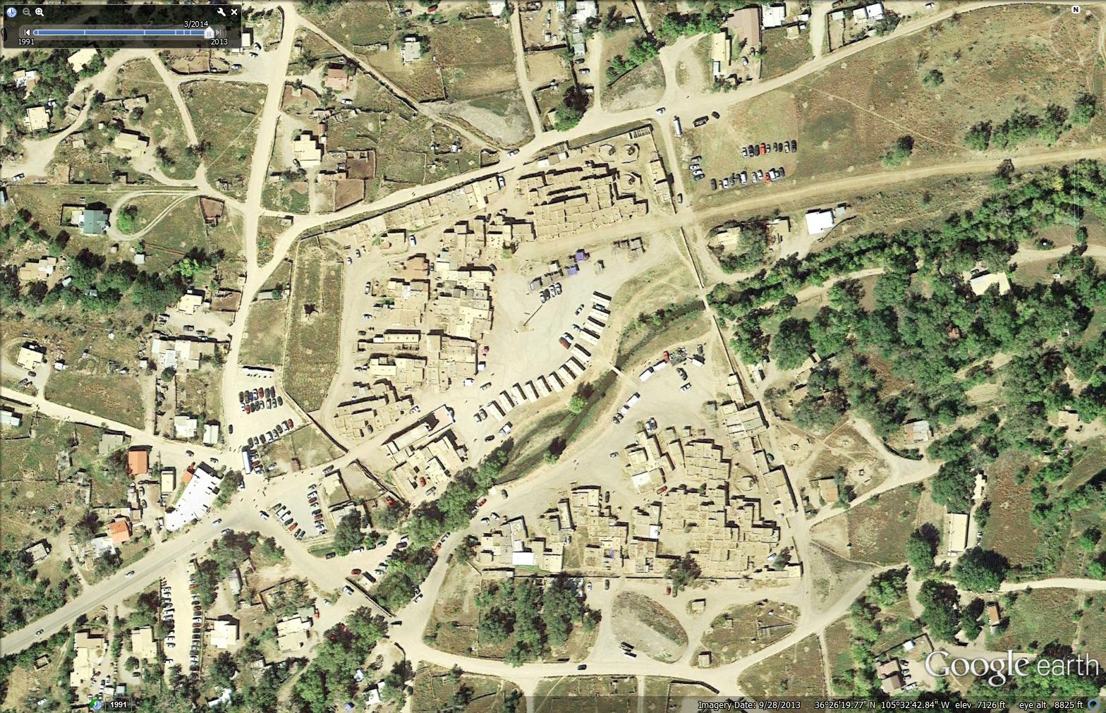
TAOS:
Most archeologists believe that the Taos Indians, along with other
Pueblo Indians, settled along the Rio Grande after migrating south
from the Four Corners region. The dwellings of that region were
inhabited by the Ancestral Puebloans. A long drought in the area in
the late 13th century may have caused them to move to the Rio
Grande, where the water supply was more dependable.
More
Pictures by James Q Jacobs , 1999,
Satellite Picture, The
Southwest Ancient Map. Ancestral
Puebloans Immigration.
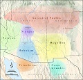
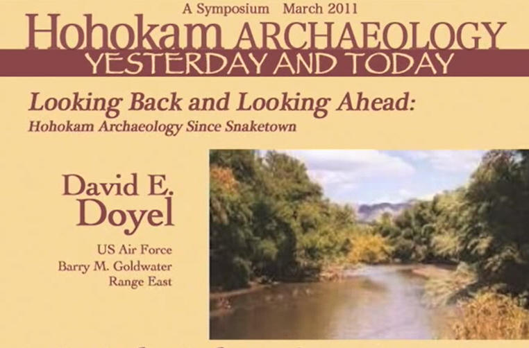
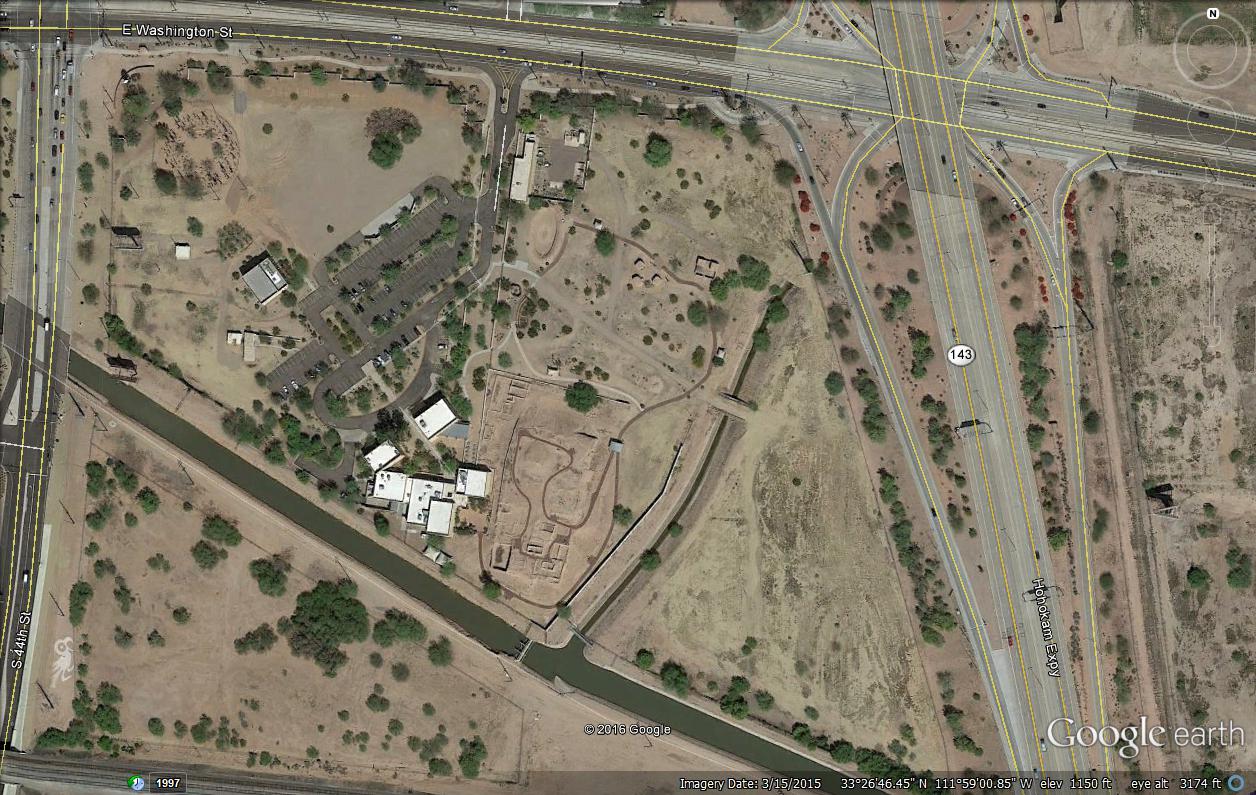
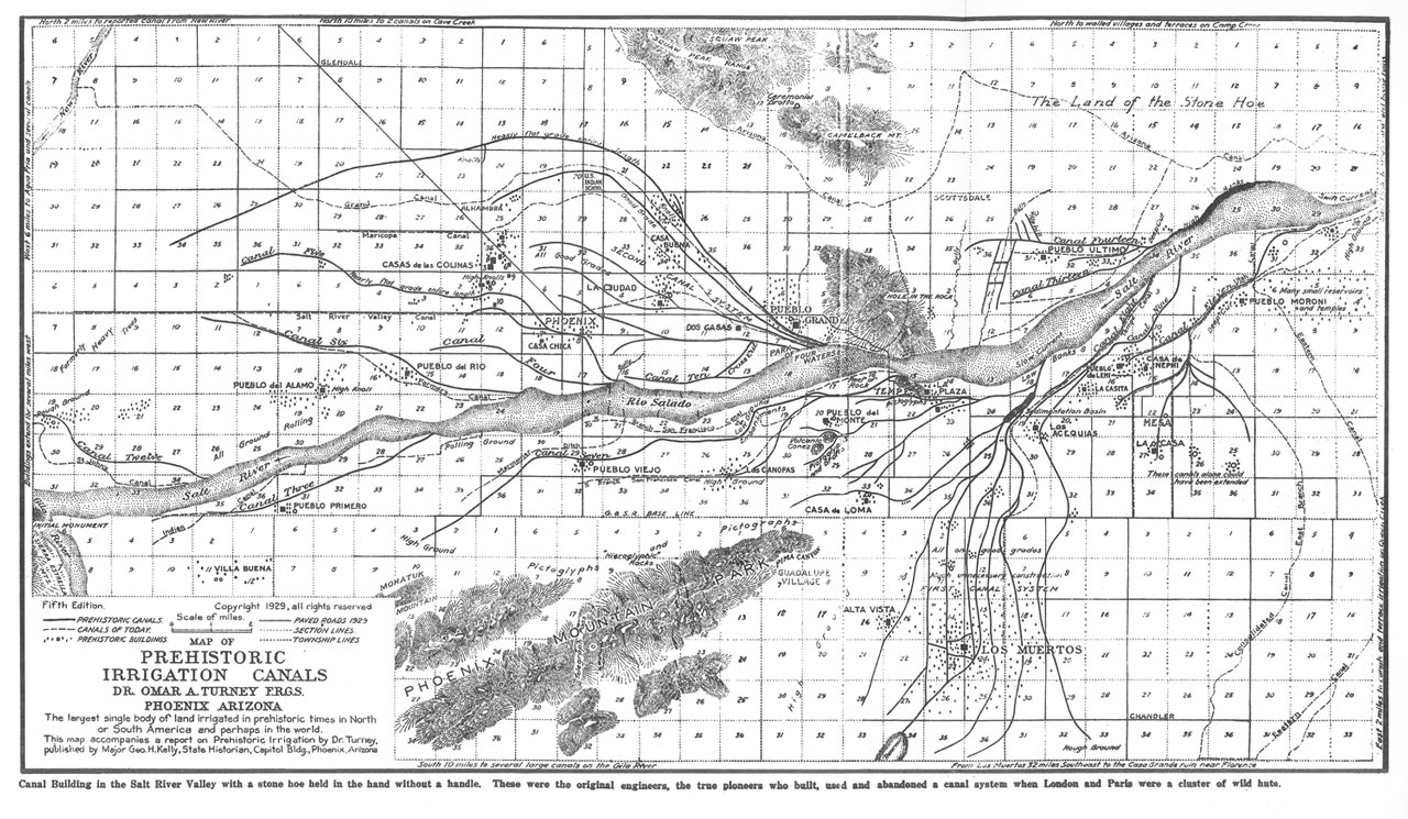
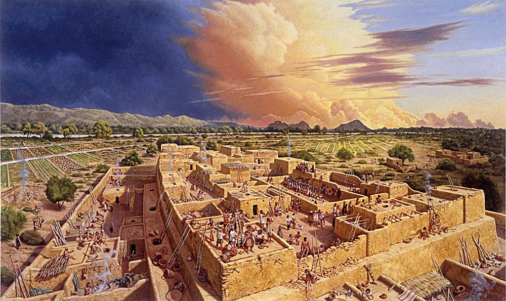
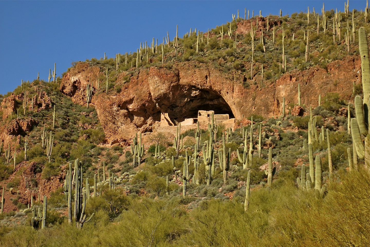
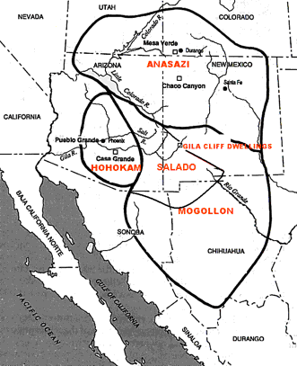
HOHOKAM CULTURE:
Hohokam,
was an ancient agricultural culture of S Arizona (c.300�1200 A.D.).
The Hohokam are noted for their extensive irrigation systems but
also built sunken ball-courts, pyramidal mounds, and other
structures similar to those of central Mexico. Most archaeologists
believe that Hohokam culture evolved from local antecedents,
although they did trade with more southerly groups. Their fate and
possible ancestry of the Pima and Tohono O'Odham (Papago) is widely
disputed. Satellite Picture () Irrigation Cannals.
Satellite Picture (Pueblo Grande)
Satellite Picture (Hohokan
Irrigation Cannals) Hohokan
Reconstruction, The
Southwest Ancient Map
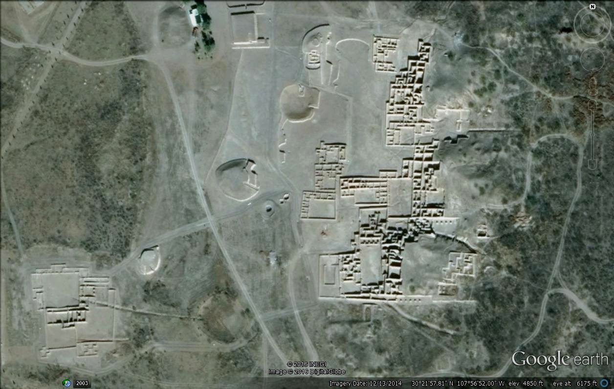
MOGOLLON CULTURE:
Mogollon
noun. A Native American culture flourishing from the 2nd century
B.C. to the 13th century A.D. in southeast Arizona and southwest New
Mexico, and Northern MExico, especially noted for its development of pottery.
The
Southwest Ancient Map.
Satellite Picture (Paquime/Casas
Grandes) Paquime Reconstruction
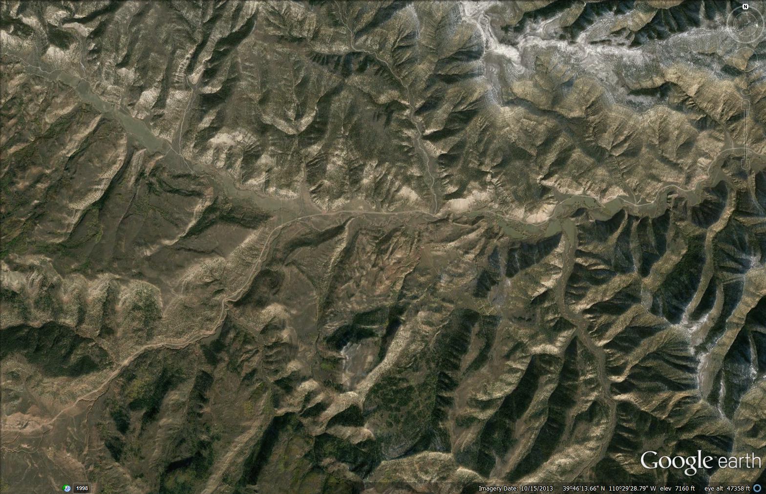
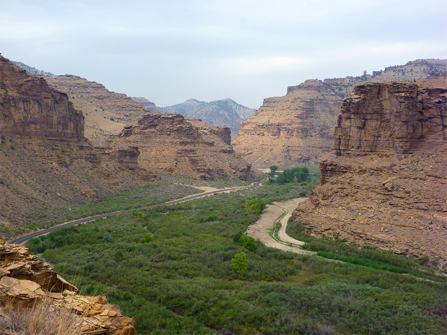
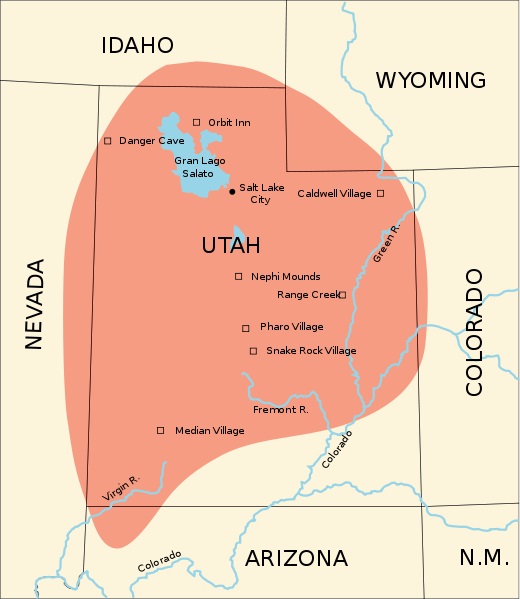
FREMONT CULTURE:
Fremont is
the name given to diverse groups of Native Americans that inhabited
the western Colorado Plateau and the eastern Great Basin from 400
A.D. to 1350 A.D. Fremont Indians lived along streambeds and raised
their families in this desolate land several hundred years longer
than the descendents of European emigrants have lived in America.
The barren, semi-arid land where the Fremont Indians lived contains
areas of spectacular beauty. Satellite
Picture, Canyon Picture,
Excellent Pictures
by James Q. Jacobs, 1999. Fremont Indians
Map
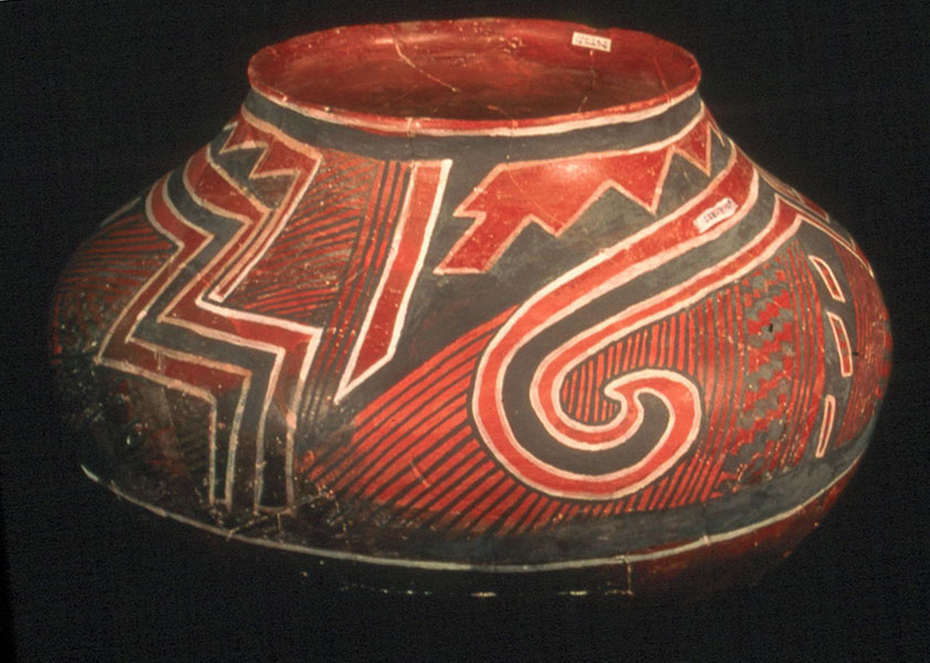
SALADO INDIANS:
The Salado Culture represents a mixture of Mogollon, Hohokam
and Anasazi peoples. The Hohokam and Mogollon had already been
interacting in this area for some time, but it was not until the
first influx of Anasazi peoples, probably originating from the
Little Colorado area, that this mixture of peoples began to develop
its own distinct character. This occured around 1100 AD, and is
evidenced in the appearance at this time of black-on-white pottery
types. Satellite Picture,
Lower Cliff Dwelling,
Salado Pottery, Salado Indians Map
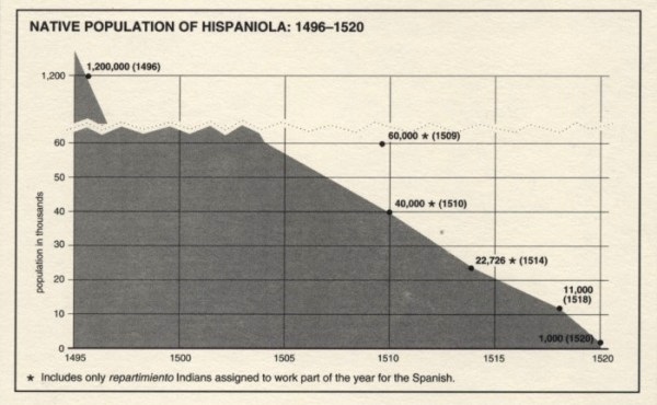
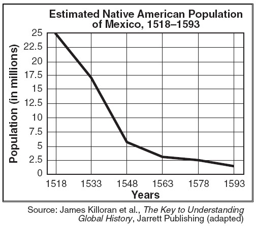
AMERICAN INDIAN
POPULATION ESTIMATES: The
population figure for indigenous peoples in the Americas before the
1492 voyage of Christopher Columbus has proven difficult to
establish in exact numbers. Scholars rely on archaeological data and
written records from settlers from the Old World. Most scholars
writing at the end of the 19th century estimated the pre-Columbian
population as low as 10 million; by the end of the 20th century most
scholars gravitate to a middle estimate of around 50 million, with
some historians arguing for 100 million or more. Contact with the
New World led to the European colonization of the Americas, in which
millions of immigrants from the Old World eventually settled the New
World. Hispaniola Indian Population
Decline, Mexico Indian Population
Decline, Current (2011) American
Indian Population Share Map.
THE POWATHAN WAR, 1610:
The Anglo-Powhatan Wars were three wars fought between English
settlers of the Virginia Colony, and Indians of the Powhatan
Confederacy in the early seventeenth century. The First War started
in 1610, and ended in a peace settlement in 1614. Another war
between the two powers lasted from 1622 to 1626. The third War
lasted from 1644 until 1646, and ended when Opechancanough was
captured and killed.
History of
Jamestown
THE KING PHILLIP'S WAR, 1675:
The war was the single greatest calamity to occur in seventeenth
century Puritan New England and is considered by many to be the
deadliest war in the history of European settlement in North America
in proportion to the population. In the space of little more than a
year, twelve of the region's towns were destroyed and many more
damaged, the colony's economy was all but ruined, and its population
was decimated, losing one-tenth of all men available for military
service. More than half of New England's towns were attacked by
Native American warriors.
Excellent
Lecture on the War,
History of
Plymouth.
THE PUEBLO
REVOLT, 1680: The Pueblo
Revolt of 1680 � also known as Pop� Rebellion � was an uprising of
most of the indigenous Pueblo people against the Spanish colonizers
in the province of Santa Fe de Nuevo M�co, present day New Mexico.
The Pueblo Revolt killed 400 Spanish and drove the remaining 2,000
settlers out of the province. Twelve years later the Spanish
returned and were able to reoccupy New Mexico with little
opposition.
The Pueblo Revolt Lecture,
History of the
Pueblo People.
History of the
Southwest.
THE PONTIAC REBELLION 1763:
The war began in May 1763 when Native Americans, offended by the
policies of British General Jeffrey Amherst, attacked a number of
British forts and settlements. Eight forts were destroyed, and
hundreds of colonists were killed or captured, with many more
fleeing the region. Hostilities came to an end after British Army
expeditions in 1764 led to peace negotiations over the next two
years. Native Americans were unable to drive away the British, but
the uprising prompted the British government to modify the policies
that had provoked the conflict.
Pontiac
Rebellion Video
TECUMSEH AND THE WAR OF 1812:
Tecumseh was a Native American leader of the Shawnee and a large
tribal confederacy (known as Tecumseh's Confederacy) which opposed
the United States during Tecumseh's War and became an ally of
Britain in the War of 1812.
Tecumseh's
Vision Video
JOHN ROSS 1790-1866:
(October 3, 1790 � August 1, 1866), also known as Koo-wi-s-gu-wi
(meaning in Cherokee a "Little White Bird"), was the Principal Chief
of the Cherokee Nation from 1828�1866, serving longer in this
position than any other person. Described as the Moses of his
people,[1] Ross influenced the Indian nation through such tumultuous
events as the relocation to Indian Territory and the American Civil
War. The Trail
of Tears Video.
BLACK HAWK WAR, 1832:
The Black Hawk War was a conflict, between the United States and
Native Americans, led by Black Hawk, a Sauk leader. The war erupted
soon after, Black Hawk and a group of Sauks, Meskwakis, and
Kickapoos, known as the "British Band", crossed the Mississippi
River, into the US state of Illinois, from Iowa Indian Territory in
April 1832. Black Hawk's motives were ambiguous, but he was
apparently hoping to avoid bloodshed while, resettling on tribal
land, that had been ceded to the United States, in the disputed 1804
Treaty of St. Louis.
The Black Hawk
War Video
OSCEOLA AND THE SEMINOLE WARS, 1835:
The Second Seminole War, also known as the Florida War, was a
conflict from 1835 to 1842 in Florida between various groups of
Native Americans collectively known as Seminoles and the United
States, part of a series of conflicts called the Seminole Wars. The
Second Seminole War, often referred to as the Seminole War, is
regarded as "the longest and most costly of the Indian conflicts of
the United States.
The Seminole
War Video
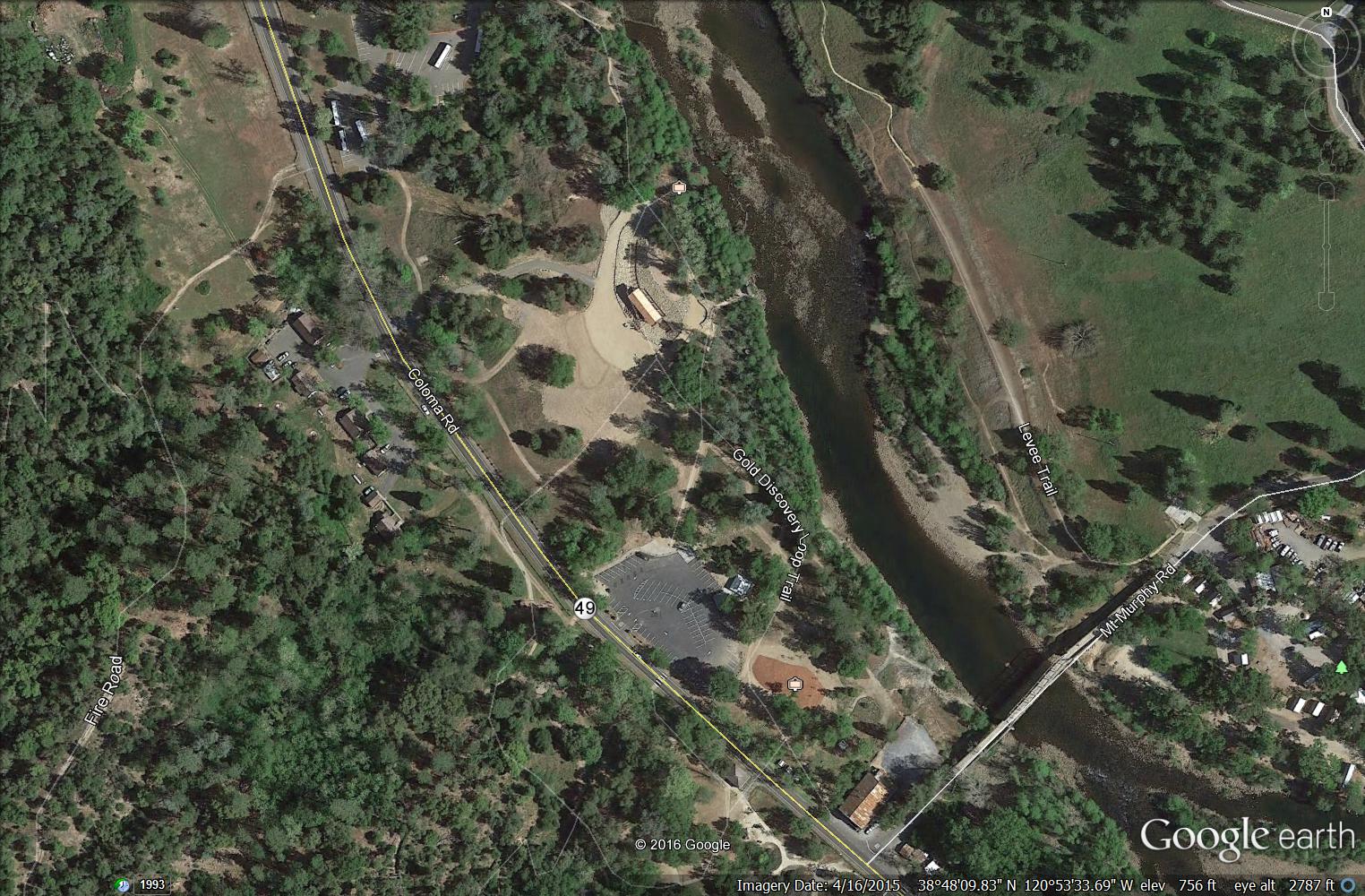
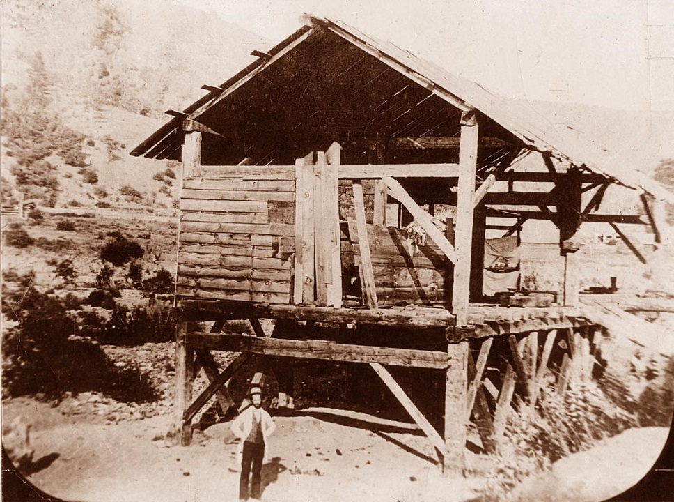
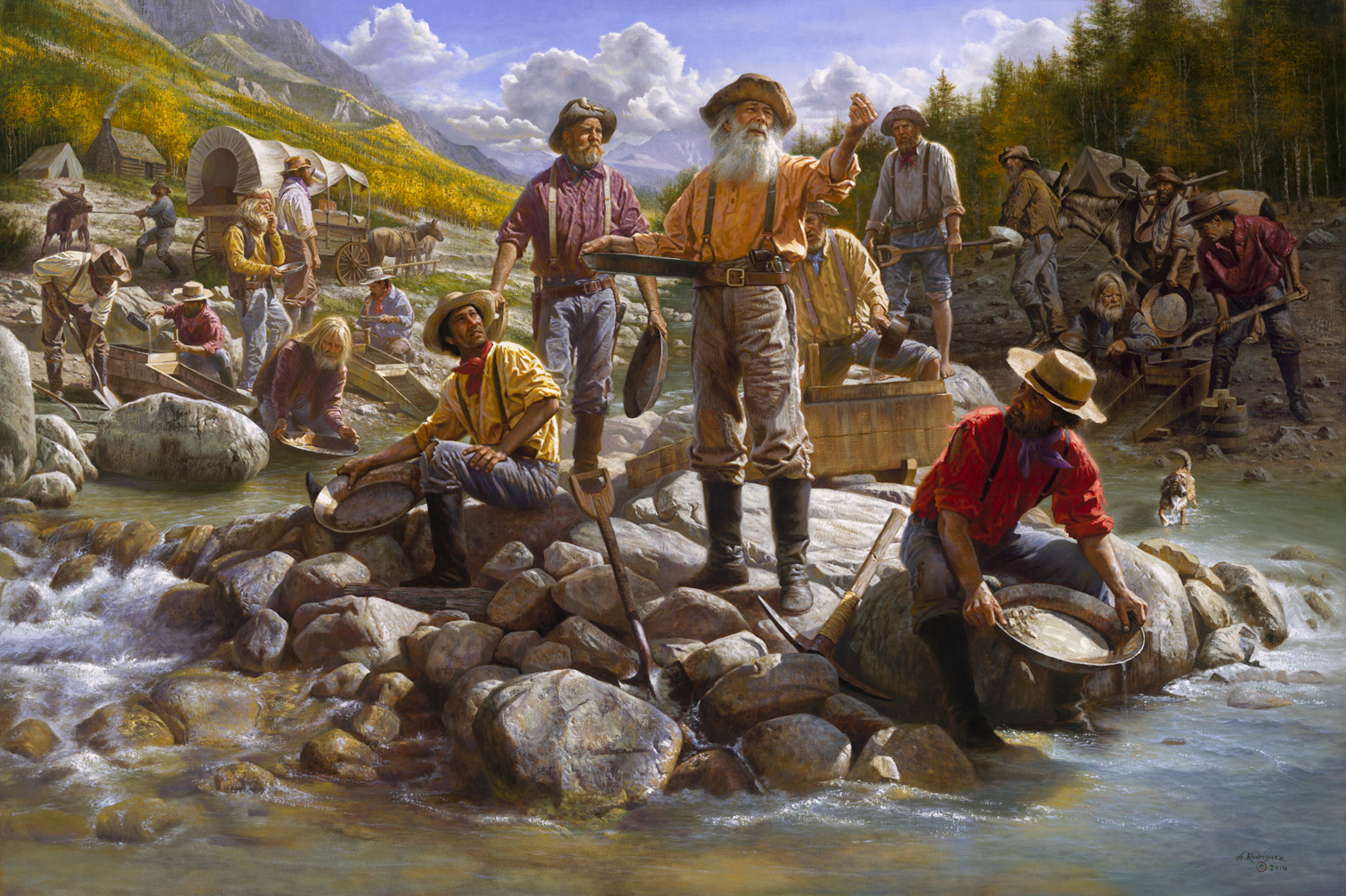
THE WEST, GOLD RUSH OF 1849:
The California Gold Rush (1848�1855) was a period in American
history which began on January 24, 1848, when gold was found by
James W. Marshall at Sutter's Mill in Coloma, California. The news
of gold brought�mostly by sailing ships and covered wagons�some
300,000 gold-seekers (called "forty-niners", as in "1849") to
California. While most of the newly arrived were Americans, the Gold
Rush also attracted some tens of thousands from Latin America,
Europe, Australia and Asia. Satellite
Picture (Sutter's Mills) Sutter's
Mills, 49's Miners.
MANUELITO, 1818-1893:
Manuelito was a prominent Navajo leader who rallied his nation
against the oppression of the United States military. For several
years he led a group of warriors in resisting federal efforts to
forcibly remove the Navajo people to Bosque Redondo, New Mexico via
the Long Walk in 1864. After being relocated to Bosque Redondo,
Manuelito was among the leaders who signed the 1868 treaty, ending a
period of imprisonment in United States government internment camps
and establishing a reservation for the Navajo.
The Long Walk
of the Navajos Video
CHIEF JOSEPH 1840-1904:
Hin-mah-too-yah-lat-kekt, Hinmat�alahtqit in Americanist
orthography, popularly known as Chief Joseph or Young Joseph (March
3, 1840 � September 21, 1904), succeeded his father Tuekakas (Chief
Joseph the Elder) as the leader of the Wal-lam-wat-kain (Wallowa)
band of Nez Perce, a Native American tribe indigenous to the Wallowa
Valley in northeastern Oregon, in the interior Pacific Northwest
region of the United States.
The Nez Perse
and Chief Joseph Video
SITTING BULL, 1831-1890:
Sitting Bull, c. 1831 � December 15, 1890) was a Hunkpapa Lakota
holy man who led his people during years of resistance to United
States government policies. He was killed by Indian agency police on
the Standing Rock Indian Reservation during an attempt to arrest
him, at a time when authorities feared that he would join the Ghost
Dance movement.
Sitting Bull Biography Video
CRAZY HORSE, 1840-1877:
(Lakota: Ta��1;ke Witk� Standard Lakota Orthography, literally
"His-Horse-Is-Crazy"; c. 1840 � September 5, 1877) was a Native
American war leader of the Oglala Lakota. He took up arms against
the United States Federal government to fight against encroachments
on the territories and way of life of the Lakota people, including
leading a war party to victory at the Battle of the Little Bighorn
in June 1876.
Crazy
Horse Biography Video
CAPTAIN JACK, 1872-1873:
Kintpuash, also known as Captain Jack (c.1837 � October 3, 1873),
was a chief of the Modoc tribe of California and Oregon. He led a
band from the Klamath Reservation to return to their lands in
California, where they resisted return. From 1872 to 1873, their
small force made use of the lava beds, holding off more numerous
United States Army forces for months in the Modoc War.
The Modoc War
Video
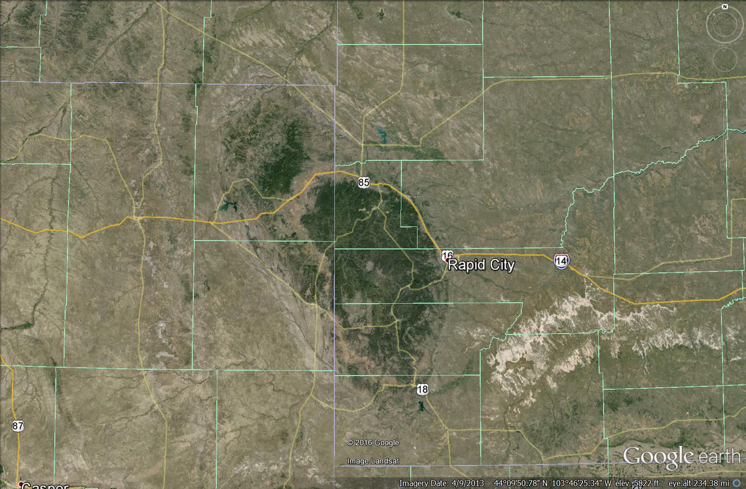
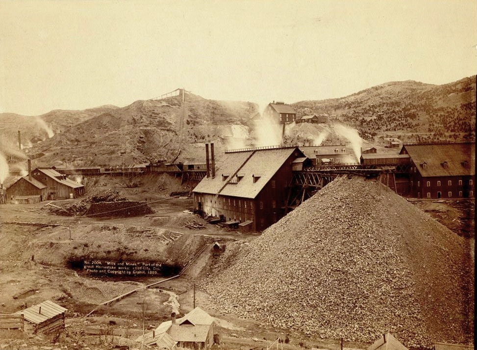
INDIAN
WARS, BLACK HILLS GOLD RUSH, 1879:The
Black Hills Gold Rush took place in Dakota Territory in the United
States. It began in 1874 following the Custer Expedition and reached
a peak in 1876-77. In the 1860s, Roman Catholic missionary
Father De Smet is reported to have seen Sioux Indians carrying gold
which they told him came from the Black Hills. Prior to the Gold
Rush, the Black Hills were used by Native Americans (primarily bands
of Sioux but others also ranged through the area). The United States
government recognized the Black Hills as belonging to the Sioux by
the Treaty of Laramie in 1868. Despite being within Indian
territory, and therefore off-limits, white Americans were
increasingly interested in the gold-mining possibilities of the
Black Hills. Satellite Picture
(Black Hills) Homestead Mine
GERONIMO, 1850-1886:
Geronimo (Mescalero-Chiricahua: Goyathlay "the one who
yawns"; June 16, 1829 � February 17, 1909) was a prominent leader
from the Bedonkohe band of the Chiricahua Apache tribe. From 1850 to
1886 Geronimo joined with members of three other Chiricahua Apache
bands�the Chihenne, the Chokonen and the Nednhi�to carry out
numerous raids and commit widespread attacks in the northern Mexico
states of Chihuahua and Sonora, and in the southwestern American
territories of New Mexico and Arizona.
Geronimo
Biography Video
WOUNDED KNEE, 1890:
On the morning of December 29, the troops went into the camp to
disarm the Lakota. One version of events claims that during the
process of disarming the Lakota, a deaf tribesman named Black Coyote
was reluctant to give up his rifle, claiming he had paid a lot for
it. A scuffle over the rifle escalated, and a shot was fired which
resulted in the 7th Cavalry opening fire indiscriminately from all
sides, killing men, women, and children, as well as some of their
fellow soldiers. The Lakota warriors who still had weapons began
shooting back at the attacking soldiers, who quickly suppressed the
Lakota fire. The surviving Lakota fled, but cavalrymen pursued and
killed many who were unarmed.
Wounded Knee
1890;
Wounded Knee,
We Shall Remain
OCCUPATION OF ALCATRAZ (1969):
The Occupation of Alcatraz was an occupation of Alcatraz Island by
89 American Indians who called themselves Indians of All Tribes (IOAT).[1]
The Alcatraz Occupation lasted for nineteen months, from November
20, 1969, to June 11, 1971, and was forcibly ended by the U.S.
government.
TRAIL OF BROKEN TREATIES (1972):
The Trail of Broken Treaties was a cross-country protest that was
staged in the autumn of 1972 in the United States by American Indian
and First Nations organizations. Designed to bring national
attention to American Indian issues, such as treaty rights, living
standards, and inadequate housing, it brought to the national
capital the largest gathering ever of American Indians presenting
their hopes.
The caravan began on the west coast of North America in October,
with protesters traveling by car, bus, and van. It reached the
national capital of Washington, D.C. in early November (the week
before the day of the presidential election). This was the largest
gathering ever in the capital of American Indians wanting to meet
with government to discuss their needs and negotiate a new
relationship.
WOUNDED KNEE INCIDENT(1973):
The Wounded Knee incident began on February 27, 1973, when
approximately 200 Oglala Lakota and followers of the American Indian
Movement (AIM) seized and occupied the town of Wounded Knee, South
Dakota, on the Pine Ridge Indian Reservation. The protest followed
the failure of an effort of the Oglala Sioux Civil Rights
Organization (OSCRO) to impeach tribal president Richard Wilson,
whom they accused of corruption and abuse of opponents.
Additionally, protesters attacked the United States government's
failure to fulfill treaties with Native American people and demanded
the reopening of treaty negotiations.
500 Nations Videos: - 500
Nations Episode 1:
Wounded Knee Legacy and the Ancestors
- 500 Nations Episode 2:
Mexico
- 500 Nations Episode 3:
Clash of Culture
- 500 Nations Episode 4:
Invasion of the Coast
- 500 Nations Episode 5: Cauldron of War
- 500 Nations Episode 6: Removal
- 500 Nations Episode 7: Road Across the Plains
- 500 Nations Episode 8: Attack on Culture
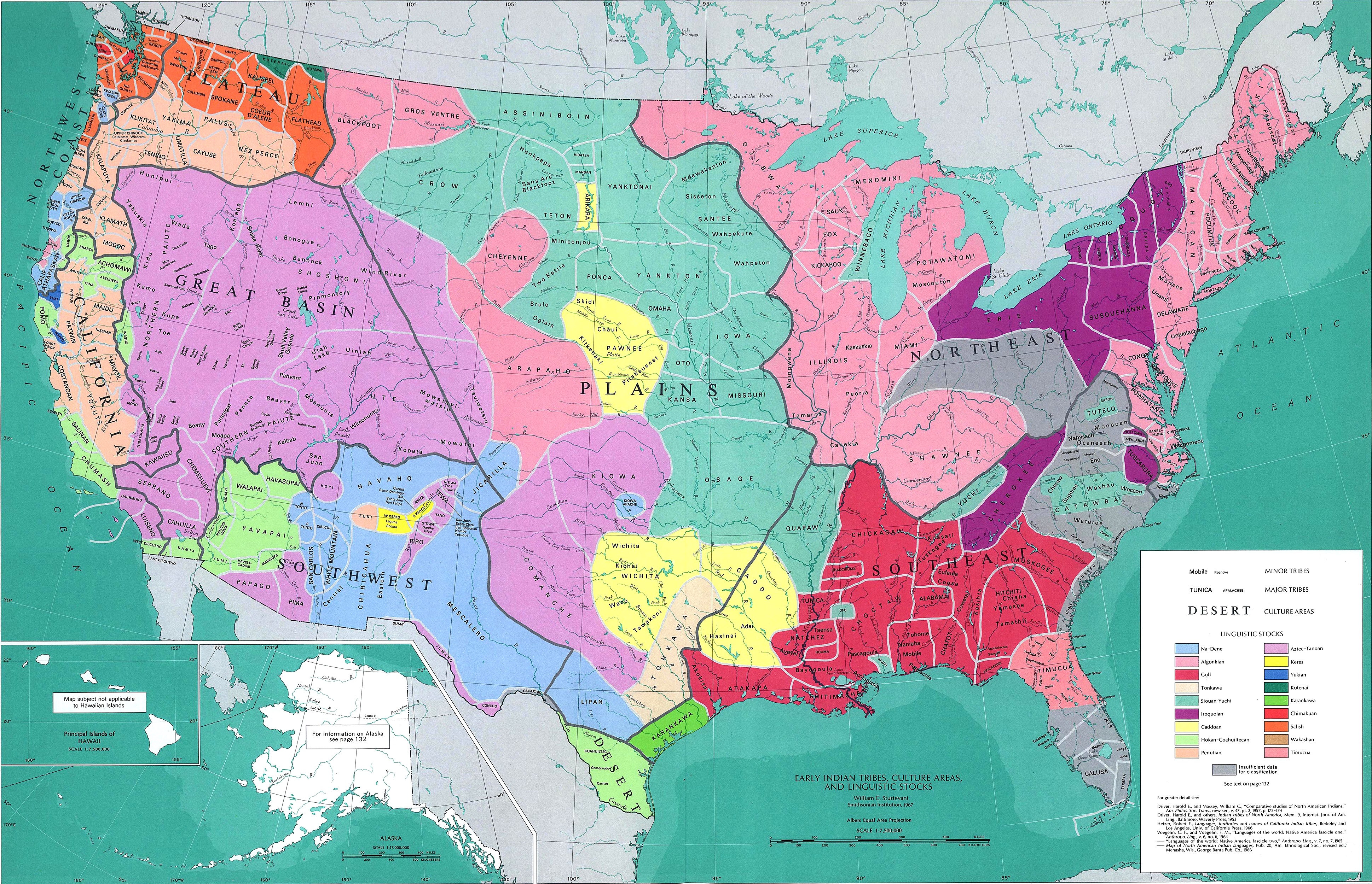
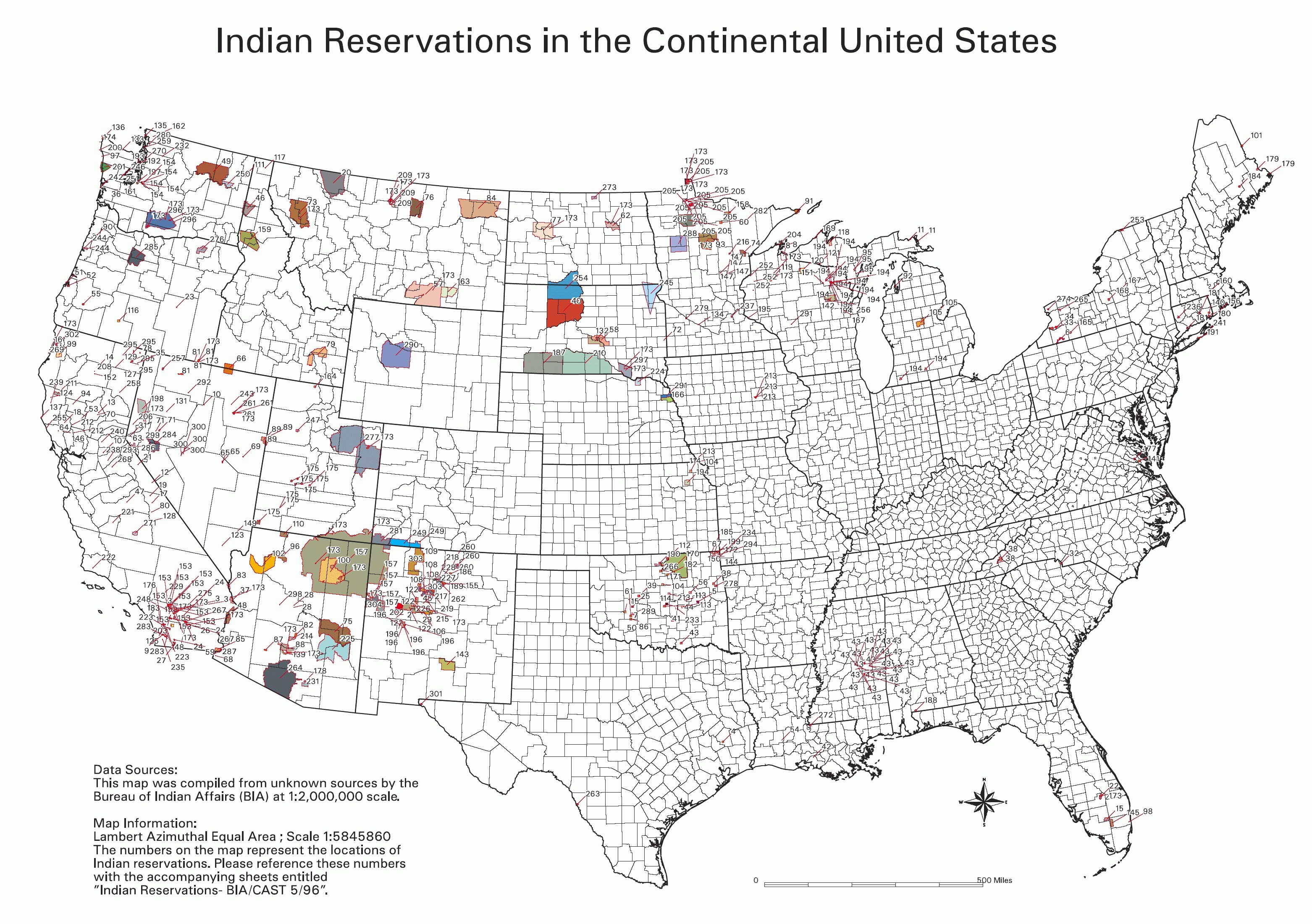
NORTH AMERICAN NATIVE PEOPLE:
In the United States, Native Americans are considered to be people
whose pre-Columbian ancestors were indigenous to the lands within
the nation's modern boundaries. These peoples were composed of
numerous distinct tribes, bands, and ethnic groups, and many of
these groups survive intact today as sovereign nations.
Map of Indian Groups in United States.
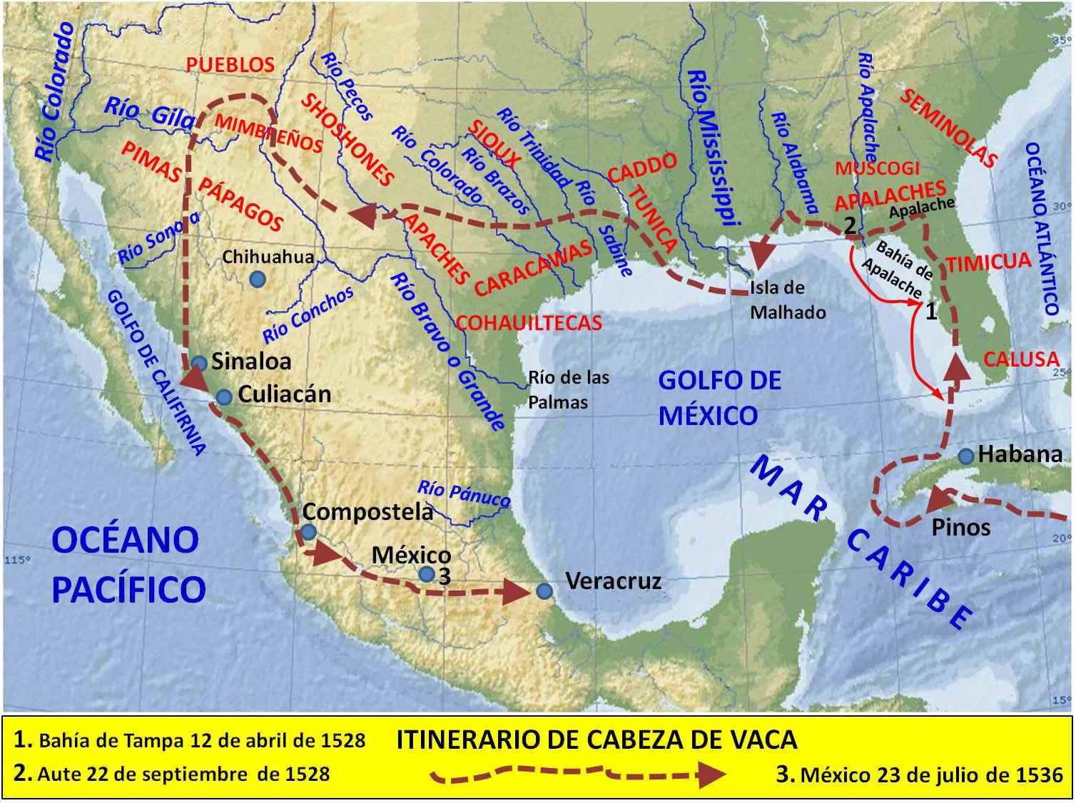
INDIGENOUS PEOPLE IN THE AMERICAS:
The indigenous peoples of the Americas are the pre-Columbian
inhabitants of North and South America, and their descendants.
Pueblos ind�nas (indigenous peoples) is a common term in
Spanish-speaking countries. Aborigen (aboriginal/native) is used in
Argentina, whereas "Amerindian" is used in Quebec and The Guianas
but not commonly in other countries. Indigenous peoples are commonly
known in Canada as Aboriginal peoples, which include First Nations,
Inuit, and M�s peoples. Indigenous peoples of the United States
are commonly known as Native Americans or American Indians, and
Alaska Natives.
At first, these people were hunters, using flint weapons and tools.
In Mexico, about 7000-6000 B.C., they founded farming cultures and
developed crops, such as corn and squash. Eventually, they created
complex civilizations�the Olmec, Toltec, Aztec, and Maya and, in
South America, the Inca. Carbon-14 tests show that humans lived
about 8000 B.C. near what are now Front Royal, VA, Kanawha, WV, and Dutchess Quarry, NY. The Hopewell Culture, based on farming,
flourished about 1000 B.C.; remains of it are seen today in large
mounds in Ohio and other states.
On the other
hand, Native Americans believe on the Creation of the World and the
Indian people. Many not different stories of the creation of
Indian people are handle down to the new generations. Native
Americans do not believe in the Bering Strait theory and even some
of us consider that theory very offensive.
Norsemen (Norwegian Vikings sailing out of Iceland and Greenland)
are credited by most scholars with being the first Europeans to
discover America, with at least 5 voyages occurring about A.D. 1000
to areas they called Helluland, Markland, Vinland�possibly what are
known today as Labrador, Nova Scotia or Newfoundland, and New
England.
Indian Tribes in United States and Canada
HAWAIIAN NATIVE PEOPLE:
To understand
Hawaiian native history and culture, one must understand the
greater Polynesian phenomenon. Hawaii is the apex of the Polynesian
Triangle, a region of the Pacific Ocean anchored by three island
groups: Hawaii, Rapa Nui (Easter
Island) and Aotearoa (New Zealand). The many island cultures
within the Polynesian Triangle share similar languages derived from
a proto-Malayo-Polynesian language used in Southeast Asia 5000 years
ago. Polynesians also share fundamentally similar cultural
traditions, arts, religion, sciences. Anthropologists believe that
all Polynesians have a common connection to a single proto-culture
established in the South Pacific by migrant Austronesian
(Malayo-Polynesian) people.
Excellent Pictures
Everybody knows
who Christopher Columbus was, but very few know the name of the
first Native who welcomed Columbus. to the Americas. The main
objective of the "Amauta" Info Website is to educate people about
the little known history of the America's Indigenous people.
The President of the United States, Barack
Obama said:
"America's journey has been marked both by bright times of
progress and dark moments of injustice for American Indians and
Alaska Natives. Since the birth of America, they have contributed
immeasurably to our country and our heritage, distinguishing
themselves as scholars, artists, entrepreneurs, and leaders in all
aspects of our society. Native Americans have also served in the
United States Armed Forces with honor and distinction, defending the
security of our Nation with their lives. Yet, our tribal communities
face stark realities, including disproportionately high rates of
poverty, unemployment, crime, and disease. These disparities are
unacceptable, and we must acknowledge both our history and our
current challenges if we are to ensure that all of our children have
an equal opportunity to pursue the American dream. From upholding
the tribal sovereignty recognized and reaffirmed in our Constitution
and laws to strengthening our unique nation-to- nation relationship,
my Administration stands firm in fulfilling our Nation's
commitments.
President of USA Barack Obama on October 29, 2010
National American Indian Heritage Month Proclamation
The President of the United States, George W.
Bush said:
"The strength of our Nation comes from its people. As the
early inhabitants of this great land, the native peoples of North
America played a unique role in the shaping of our Nation's history
and culture...I call on all Americans to learn more about the
history and heritage of the Native peoples of this great land. Such
actions reaffirm our appreciation and respect for their traditions
and way of life and can help to preserve an important part of our
culture for generations yet to come."
President of USA George W. Bush on November 19, 2001
National American Indian Heritage Month Proclamation
The President of the United States, William J.
Clinton said:
"So much of who we are today comes from who you have been for long
time. Long before others came to the shores there were powerful and
sophisticated cultures and societies here--yours. Because of your
ancestors, democracy existed here long before the Constitution was
drafted and ratified...I believe in your rich heritage and in our
common destiny. What you have done to retain your identity,
your dignity and your faith in the face of often immeasurable
obstacles is profoundly moving--an example of the enduring strength
of the human spirit.""
President of USA Williams J. Clinton on April 29, 1994
From the Book: Native Time written by Lee Francis, pp. 328-329
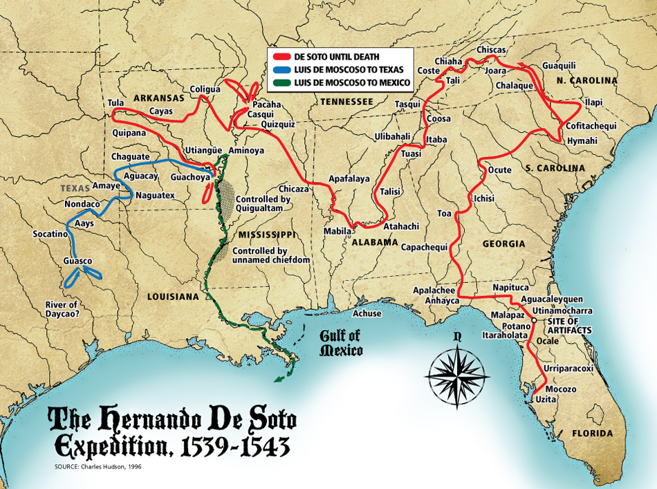
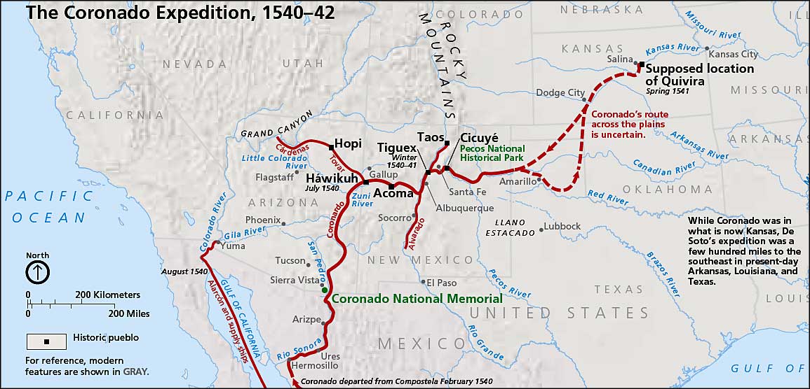
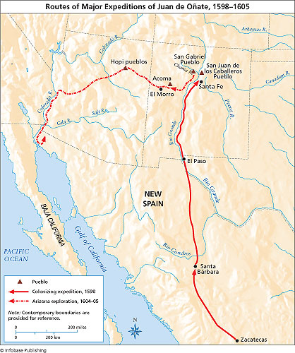
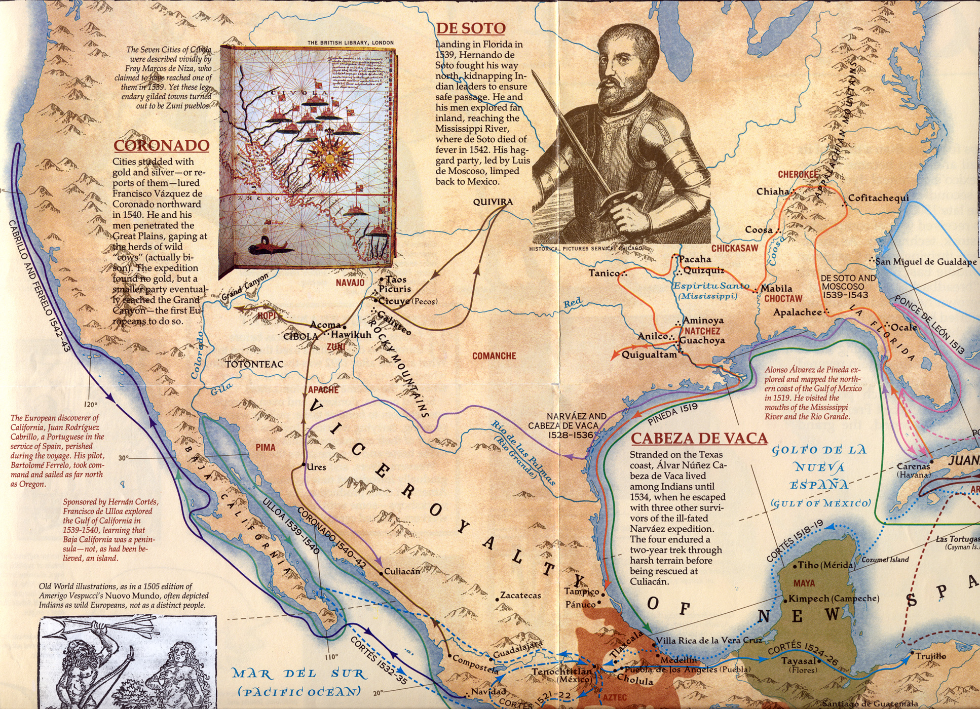
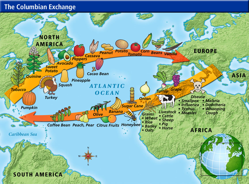
EUROPEAN CONTACT AND IMPACT It is
estimated that at the time of first European contact, North and
South America was inhabited by more than 90 million people (some
said 120 million): about 10 million in America north of present-day
Mexico; 30 million in Mexico; 11 million in Central America; 445,000
in the Caribbean islands; 30 million in the South American Andean
region; and 9 million in the remainder of South America. These
population figures are a rough estimate (some authorities cite much
lower figures); exact figures are impossible to ascertain. When
colonists began keeping records, the Native American populations had
been drastically reduced by war, famine, forced labor, and epidemics
of diseases introduced through contact with Europeans.
As
early Europeans first stepped ashore in what they considered the
�New World��whether in San Salvador (West Indies), Roanoke Island
(North Carolina), or Chaleur Bay (New Brunswick)�they usually were
welcomed by the peoples indigenous to the Americas. Native Americans
seemed to regard their lighter-complexioned visitors as something of
a marvel, not only for their dress, beards, and winged ships but
even more for their technology�steel knives and swords,
fire-belching arquebus (a portable firearm of the 15th and
16th centuries) and cannon, mirrors, hawkbells and earrings, copper
and brass kettles, and other items unusual to the way of life of
Native Americans.
RELATION WITH THE COLONIAL POWERS �We
came here to serve God, and also to get rich,� announced a member of
the entourage of Spanish explorer and conqueror Hern�Cort� Both
agendas of 16th-century Spaniards, the commercial and the religious,
needed the Native Americans themselves in order to be successful.
The Spanish conquistadors and other adventurers wanted the land and
labor of the Native Americans; the priests and friars laid claim to
their souls. Ultimately, both programs were destructive to many
indigenous peoples of the Americas. The first robbed them of their
freedom and, in many cases, their lives; the second deprived them of
their culture.
Contrary to many stereotypes, however, many 16th-century Spaniards
agonized over the ethics of conquest. Important Spanish jurists and
humanists argued at length over the legality of depriving the Native
Americans of their land and coercing them to submit to Spanish
authority. For the Native Americans, however, these ethical debates
did little good.
THE RAVAGES OF DISEASES In
1492 the Caribbean, Mexico, Central America, and Andean South
America were among the most densely populated regions of the
hemisphere. Yet, within a span of several generations, each
experienced a cataclysmic population decline. The culprit, to a
large extent, was microbial infection: European-brought diseases
such as
smallpox, pulmonary ailments, and
gastrointestinal disorders, all of which had been unknown in the
Americas during the pre-Columbian period. Native Americans were
immunologically vulnerable to this invisible conqueror.
The
destruction was especially visible in Latin America, where great
masses of susceptible individuals were congregated in cities such as
Tenochtitl�and Cuzco, not to mention
the innumerable towns and villages dotting the countryside. More
than anything else, it was the appalling magnitude of these deaths
from disease that prompted the vigorous Spanish debate over the
morality of conquest.
As
the indigenous population in the Caribbean plummeted, Spaniards
resorted to slave raids on the mainland of what is now Florida to
bolster the work force. When the time came that this, too, proved
insufficient, they took to importing West Africans to work the cane
fields and silver mines.
Those Native Americans who did survive were often assigned, as an
entire village or community to a planter or mine operator to whom
they would owe all their services. The encomienda system, as
it came to be known, amounted to virtual slavery. This, too, broke
the spirit and health of the indigenous peoples, making them all the
more vulnerable to the diseases brought by the Europeans.
Death from microbial infection was probably not as extensive in the
Canadian forest, where most of the indigenous peoples lived as
migratory hunter-gatherers. Village farmers, such as the Huron north
of Lake Ontario, did, however, suffer serious depopulation in waves
of epidemics that may have been triggered by Jesuit priests and
their lay assistants, who had established missions in the area.
NATIVE NORTH AMERICANS TODAY
Statistics of health, education, unemployment rates, and income
levels continue to show Native Americans as disadvantaged compared
to the general population of North America. In the 1980s U.S.
government policies have led to budget cuts for social and welfare
services on the reservations. However, according to the United
States Census Bureau, the Native American population in the United
States rose more than 20 percent between 1980 and 1990. Pride in
Native American heritage has survived as well. On many reservations,
tribal languages and religious ceremonies are enjoying renewed
vigor. Traditional arts and crafts, such as Pueblo pottery and
Navajo weaving, continue to be practiced, and some contemporary
Native American artists of North America, such as Fritz Scholder and
R. C. Gorman, have successfully adapted European styles to their
paintings and prints of Native American subjects. The strength of
the Native American narrative tradition can be felt in the poetry
and novels of the Native American writer N. Scott Momaday, who won a
Pulitzer Prize in fiction for his House Made of Dawn (1969).
Other prestigious contemporary Native American writers of North
America include Vine Deloria, best known for his indictment of U.S.
policy toward Native Americans in Custer Died for Your Sins
(1969) and Behind the Trail of Broken Treaties (1974);
novelists James Welch and Leslie Marmon Silko; and William Least
Heat-Moon, author of the widely popular Blue Highways: A Journey
into America (1983), an account of his travels in the United
States.
Statistics on Native Americans in USA, Census 2000
BRIEF HISTORY OF FEDERAL INDIAN POLICY
1492-1787: Tribal Independence
- French Indian Wars (Seven Years War in 1763)
- The Iroquois and the British agreements
- The King proclaimed the liberty of Indian Nations and their
properties
1787-1828: Agreement Between Equals
- Indian Tribes as Foreign Nations
- Militarily, Indian Nations were more powerful
- 1790, the Congress prohibited whites to obtaining Indian lands
- 1793, Non-Indian were prohibited from setting on Indian lands
- The invasion of white settlers started
1828-1887: Relocations of Indian Nations
- Pte. Andrew Jackson "The Jackson Era" and the removal of
Indian Nations
- 1830, Indian Removal Act
- Gold in California and the Black Hills
- 1871, No more treaties with Indian Nations (400 treaties)
1887-1934: Allotment and Assimilation
- Policy for taking more Indian lands (From 150 million to
50 million acres)
- "Acculturation" of Indian Nations. "Take the Indian out and
leave the man"
- GAA General Allotment Act or Dawes Act
1934-1953: Indian reorganization Act
- John Collier, Commissioner of Indian Affairs
- No interference on Indian Religion
- IRA, Indian Reorganization Act or Wheeler and Howard Act
- The first policy in 100 years not undermining the status of
Indians
1953-1968: Termination Act
- 1949, the Hoover Commission recognized "Indian
Assimilation"
- They took funding from Indian Nations
- 1953, A total of 109 Tribes were affected with Resolution # 108
1968-Present
- Pte. Lyndon Johnson and the "Freedom of Choice and
Self-determination"
- Pte. Richard Nixon denounced the termination era and ended it
- Pte. Ronald Reagan and "Self-Determination Act"
GENERAL INFORMATION ABOUT NATIVE AMERICANS OR INDIANS OF THE
AMERICAS TODAY:
Estimate Numbers of Native Americans or
Indians: 40 to 70 million.
Numbers of Native Americans in United
States and Canada:
2,475,956 (USA) 799,000 (Canada)
Numbers of Native Americans or Indians in
Latin America: 39,442,000
million
(Countries with more than a million): Mexico (12m.), Peru (10.2m.),
Bolivia (4.2m.), Guatemala (4.2m.), Ecuador (3.34m.), Chile (1m.).
(Countries with less than a million): Argentina (398t.), Belize
(30t.), Brazil (243t.), Colombia (547t.), Costa Rica (32t.), El
Salvador (300t.), Guyana (28t.), Honduras (245t.), Nicaragua
(152t.), Panama (126t.), Paraguay (67t.), Surinam (10t.), and
Venezuela (331t.) (t.=thousand).
-
Indian Tribes in Latin America -
Latin American Indian Population - Up date
Problems with Statistics regarding Native Americans or Indians: In
some countries in Latin America, there are no census data for Native
people, in others, the census include complex criteria to determine
who is Native. Until few years ago, some countries denied the
existence of Native people in their territories and in many cases,
Native people denied their origin due to the pressure of
society who consider them "uncivilized". In my opinion the estimated
numbers are very low, in one of my presentations, I further explain
my position. Source: America Indigena (1-2-1992) -
Latin American Indian Population - Up date -
A Paper About Latin American Indian
Populations (Spanish)
-
Indians in Latina America, Population
(Spanish)


